Our factsheet An introduction to the historic counties discusses what the historic counties are and why they matter.
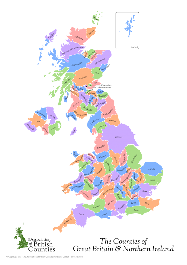
There are 92 historic counties in the UK: 39 in England, 6 in Northern Ireland, 34 in Scotland, and 13 in Wales.
Our country’s division into counties goes back to mediæval and feudal times.
The counties emerge in England
The division of England into shires began in Wessex in the mid-Saxon period. With the Wessex conquest of Mercia in the 9th and 10th centuries, the system was extended to central England. At the time of the Domesday Book, northern England comprised Cheshire and Yorkshire. The remaining counties of the north were established in the 12th century. Rutland appears in the Domesday Book, but is first recorded as a county in 1159.
The counties emerge in Scotland
The Scottish counties have their origins in the shires first created in the reign of Alexander I (1107-24), and in accordance with the pattern further south, each had a shire reeve, or sheriff. The pattern of shires that existed by the time of the late Middle Ages is believed to be very close to that existing in the mid-nineteenth century. The central and western Highlands and the Isles were not assigned to shires until the early modern period, Caithness becoming a sheriffdom in 1503 and Orkney in 1540.
The counties emerge in Wales
The first eight counties of Wales were created by King Edward I in 1284, by the Statute of Rhuddlan. The present day pattern of the historic counties was established by the Laws in Wales Act 1535, which established Denbighshire, Montgomeryshire, Radnorshire, Brecknockshire and Monmouthshire from the areas of the former marcher lordships. The historic counties are, however, based on much older, traditional areas.
The counties emerge in Ireland
The division of Ireland into counties began during the reign of King John (1199-1216). The complete set of counties as they are today was laid down in 1584 (with their modern boundaries not finally settled until 1613. As in Wales the counties were generally based on earlier, traditional areas.
The advent of modern local government
When modern local government was first created, in 1888, the areas of its “administrative counties” were based on the historic counties. Local government remained fairly closely based on the historic counties from 1888-1965. However, the cumulative effect of the numerous local government reforms since then mean that few local authorities now have an area anything like any historic county. However, the words “county” and “county council” are still used in local government terminology. Many local authorities also still use the unqualified name of an historic county, despite having a very different area from that county.
The result is confusion. The public is led to believe that cherished historic counties have been altered or abolished by local government change; despite Governments repeatedly confirming that this is not the case.
The counties today and in future
The Association believes that local government needs to be given an identity totally distinct from that of the historic counties, to the benefit of both. We champion the historic counties as the basis of our standard geography. Administrative areas are wholly unsuitable for this purpose: there are too many of them, and their names and areas change too often. Administrative areas were created to facilitate public service provision, not as a basis for geographical descriptions.
The UK desperately needs a standard, fixed, general-purpose geography, a commonly understood set of names and areas for use in all walks of life (media, business, education, tourism, sport, religion, social and cultural). This geography should be divorced from the ever-changing names and areas of local government but, instead, be rooted in history, heritage and commonly held notions of community and identity. The 92 historic counties of the UK have provided this framework for centuries and are the only credible basis for it. Unlike the constantly changing boundaries of our local authorities, the historic counties remain constant. They are therefore very useful when describing where you are from and in your postal address.
Further Reading
Useful Tools
Gazetteer of British Place Names – a comprehensive listing of the County of the cities, towns and villages of Britain.
Historic Counties Postal Directory – a directory of the Historic Counties indexed by post town.

