
Cheshire Day is celebrated on 30th March each year. On 30th March 1300, King Edward I confirmed a charter of liberties for Cheshire. In celebration we present our Map of Cheshire and our portrait of the county.
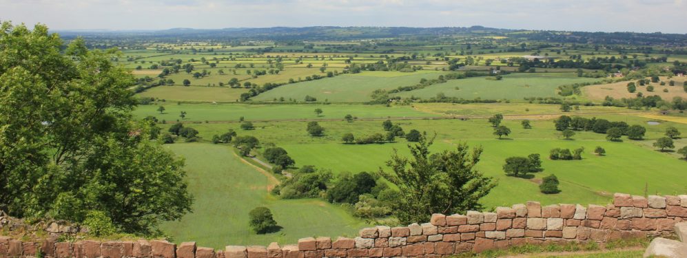
The County Palatine of Chester is a maritime county. Along Cheshire’s border with Lancashire, the rivers Mersey and Tame, are many industrial and suburban towns and villages. In its west is the City of Chester. The rest of the county has a few large towns but is largely rural. Most of Cheshire lies in the great lowland expanse of the Cheshire Plain. The Plain extends right up to the Mersey in the north. In the south it extends beyond Cheshire’s border, into Shropshire. Westwards, the Plain extends beyond Cheshire to the Welsh hills. The Plain extends eastwards to the Peak District, the eastern part of Cheshire lying in the hills.
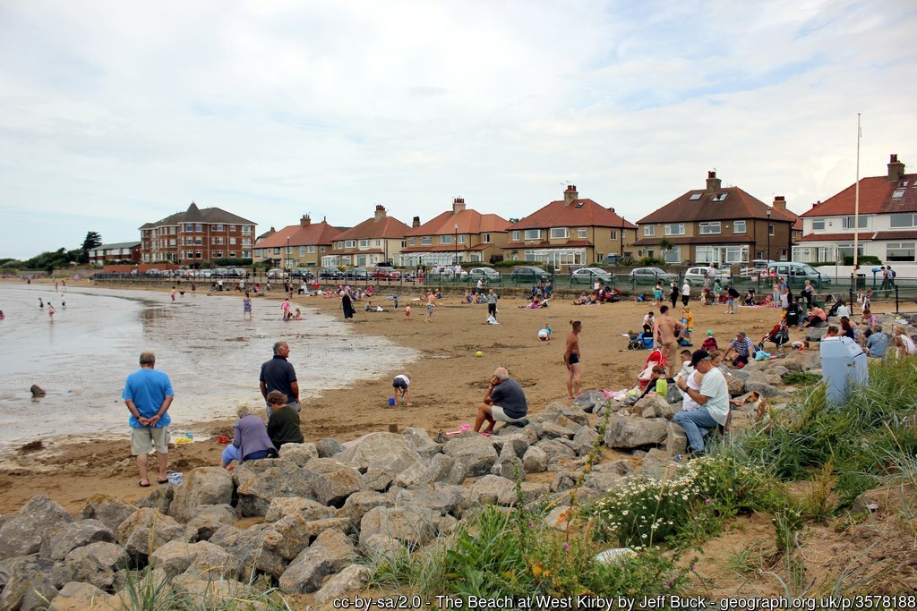
The Beach at West Kirby
In the county’s north-west is the Wirral peninsula, separating the Dee and the Mersey. The Mersey coast of the Wirral is highly urbanised. Wallasey formed as its districts merged together during the 19th and 20th centuries. Birkenhead is an ancient port. Birkenhead Priory and the Mersey Ferry were established in the 12th century. Hamilton Square is a Georgian Square designed by James Gillespie Graham. Ellesmere Port lies on the Manchester Ship Canal. The south of the Wirral has the resort of Hoylake and the towns of West Kirby and Heswall.
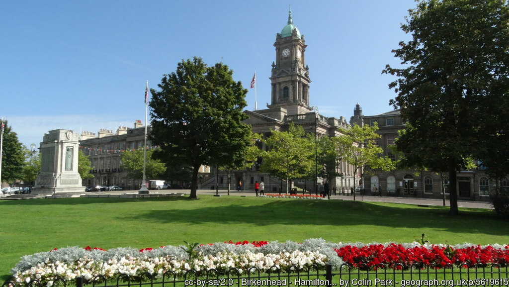
The Town Hall and War Memorial, Hamilton Square, Birkenhead
The rivers Mersey and Tame form Cheshire’s border with Lancashire. Towns and villages lie along almost the entirety of the Cheshire side. The port of Runcorn stands where the Mersey estuary narrows to form the Runcorn Gap. On the Cheshire bank of the Mersey, opposite the Lancashire town of Warrington, lie Wilderspool, Latchford, Stockton Heath and Thelwall. To the east is a few miles of countryside, then the town of Partington. Carrington Moss provides a break from the towns before a lengthy urban stretch begins at Ashton upon Mersey.
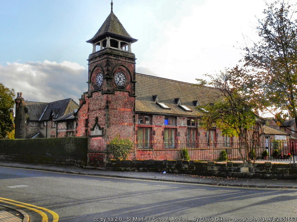
St Martins’ School, Ashton Upon Mersey
The town of Sale, east of Ashton Upon Mersey, developed as an industrial town after the arrival of the Bridgewater Canal but, with the arrival of the railway in 1849, grew quickly into a commuter town. To its south, Altrincham was established as a market town in 1290, and today is also an affluent commuter town. This area has two of Cheshire’s great country houses. West of Altrincham is the 17th-century Dunham Massey Hall (NT), surrounded by its huge deer park. East of Sale is Wythenshawe Hall, a 16th-century mediæval timber-framed manor house, seat of the Tatton family from 1540 to 1926. Wythenshawe Park comprises 270 acres of the hall’s gardens and parkland.
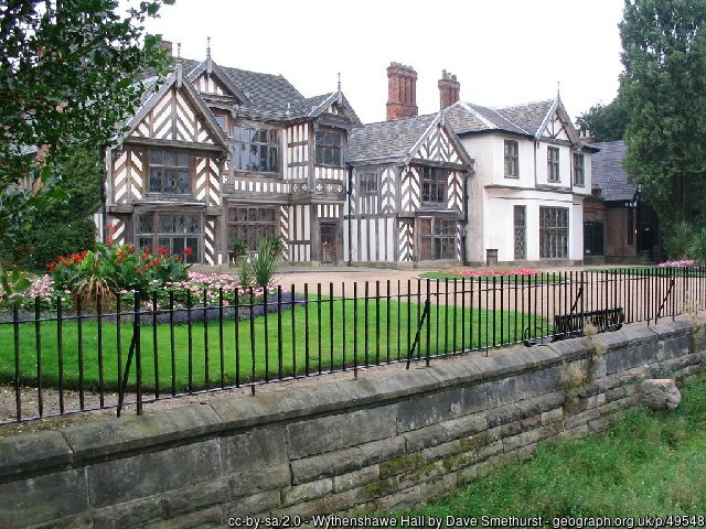
Wythenshawe Hall
Wythenshawe Hall gave its name and much of its land to the town of Wythenshawe. Wythenshawe began in the 1920s as a massive housing estate for an overspill population from Manchester. Wythenshawe now encompasses 11 square miles and many former villages including Northern Moor and Northenden. Immediately south of Wythenshawe is Manchester Airport, formerly called “Ringway Airport”. East of Wythenshawe, the villages of Gatley and Cheadle lie on the Mersey with Cheadle Hulme to their south.
The great Cheshire town of Stockport stands where the rivers Goyt and Tame meet to become the Mersey. Stockport become famous for its hatting industry. The Stockport Viaduct is a major landmark, its 27 brick arches carrying the mainline railways over the Mersey. In the 19th century Stockport spread across the Mersey into Lancashire developing around Lancashire Hill and Heaton Norris. Stockport County Football club began life in Lancashire as Heaton Norris Rovers. The club changed its name in 1890 and moved to Edgeley Park in Cheshire in 1902.
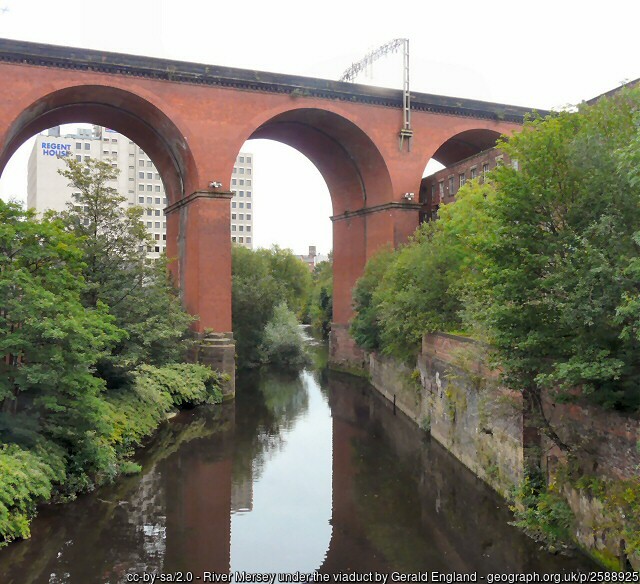
The Stockport Viaduct with the Mersey passing under it: Lancashire on left, Cheshire on right
East of Stockport, the River Tame forms Cheshire’s border with Lancashire. Bredbury is a suburban town with a long history. The ruins of Arden Hall, erected in 1597, stand in a commanding position above the Tame. East of Bredbury lies the suburb of Woodley and south lies the small town of Romiley. Goyt Hall, a half-timbered building from around 1570, lies in the Goyt Valley nearby. Further east on the Tame are the former industrial and mining towns of Hyde and Duckinfield. Stalybridge (partly in Lancashire) became one of the first centres of textile manufacture during the Industrial Revolution, though now it is semi-rural in character.
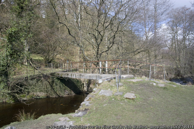
Footbridge over River Goyt
Lancashire, Yorkshire and Cheshire meet at Mossley. The Cheshire part, also known as Micklehurst, lies east of the Tame. The parish of Tintwistle runs up into the Peak District: the famous ‘panhandle’ of Cheshire between Yorkshire and Derbyshire. The county top, Black Hill, lies on the border with Yorkshire. The villages of Tintwistle and Hollingsworth lie on the Derbyshire border. West of these are the villages of Mottram in Longdendale and Broadbottom. Nearby Hattersley developed as an overspill estate.

South of the ‘panhandle’, the eastern part of Cheshire lies in the Peak District. The River Goyt forms the border with Derbyshire. The towns of Marple and Whaley Bridge stands on its banks. On the edge of the Peaks is the magnificent Lyme Park estate (NT), with its 16th-century mansion, the largest in Cheshire, surrounded by formal gardens and a deer park.
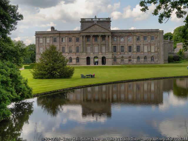
Lyme Park House
The River Dane forms the southern section of the Cheshire – Derbyshire border. Cheshire, Derbyshire and Staffordshire meet at Three Shires Head, a picturesque spot with a fabulous high-arched stone packhorse bridge and waterfalls.
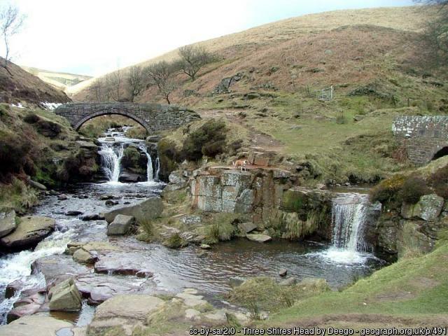
Three Shires Head, Cheshire to left, Derbyshire to right background, Staffordshire to right foreground
South of the Mersey Valley and West of the Peak District, Cheshire is predominantly rural. The Cheshire Plain has fine oak woodlands and countless small lakes or meres. Cheshire excels in dairy farming, resulting in Cheshire cheese.
Chester is an ancient city standing on the River Dee, close to the border with Flintshire. Chester was founded as the Roman fort of Deva Victrix in AD 79. Its four main roads, Eastgate, Northgate, Watergate and Bridge, follow routes laid out at this time. The most important Roman remain is the amphitheatre. The city walls comprise the most complete Roman and mediæval defensive town wall system in Britain. The Rows have shops at ground level and, up steps, a second tier of shops protected by covered walkways. Many have stone undercrofts. The Rows, in some form, have existed since the 13th century.
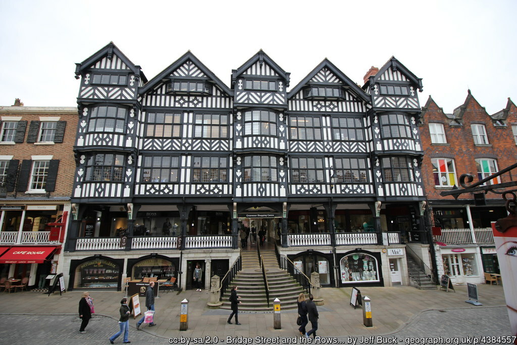
The Rows, Chester
To the east of Chester, the Cheshire Plain is bisected north to south by the low sandstone hills known as the Mid Cheshire Range. A series of Iron Age hill forts adorn the ridge from Woodhouse Hill and Helsby Hill in the north through Eddisbury and Kelsborrow Castle to Maiden Castle in the south. Beeston Castle is a former Royal castle built on Beeston Crag. Peckforton Castle, a Victorian mansion built in the style of a mediæval castle, stands on Peckforton Hill.
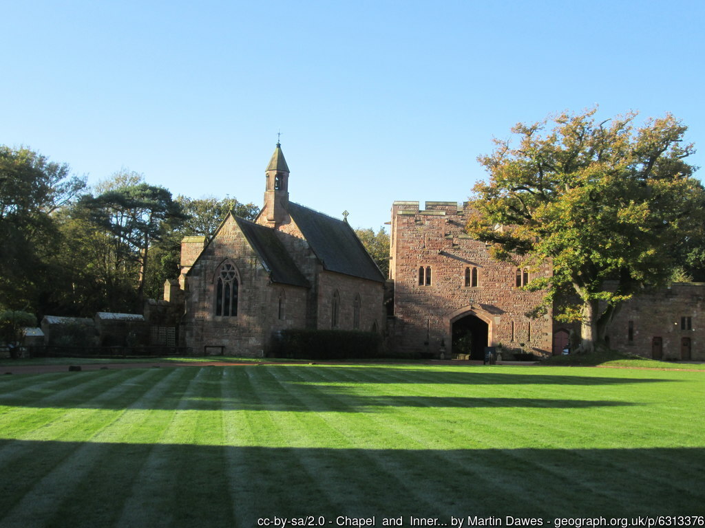
Peckforton Castle: Chapel and Inner Gatehouse
The central part of the county has been a salt-mining area since Roman times, especially around Nantwich, Northwich and Middlewich, the Three Wiches. Nantwich is an architectural gem, with streets lined with Elizabethan houses built to replace the Great Fire of 1583.
Crewe, in the south, is best known as a large railway junction and for Crewe Works, a major railway engineering facility. Nearby Sandbach is an ancient market town famous for the Sandbach Crosses, two 9th-century stone Anglo-Saxon crosses erected in the market place.
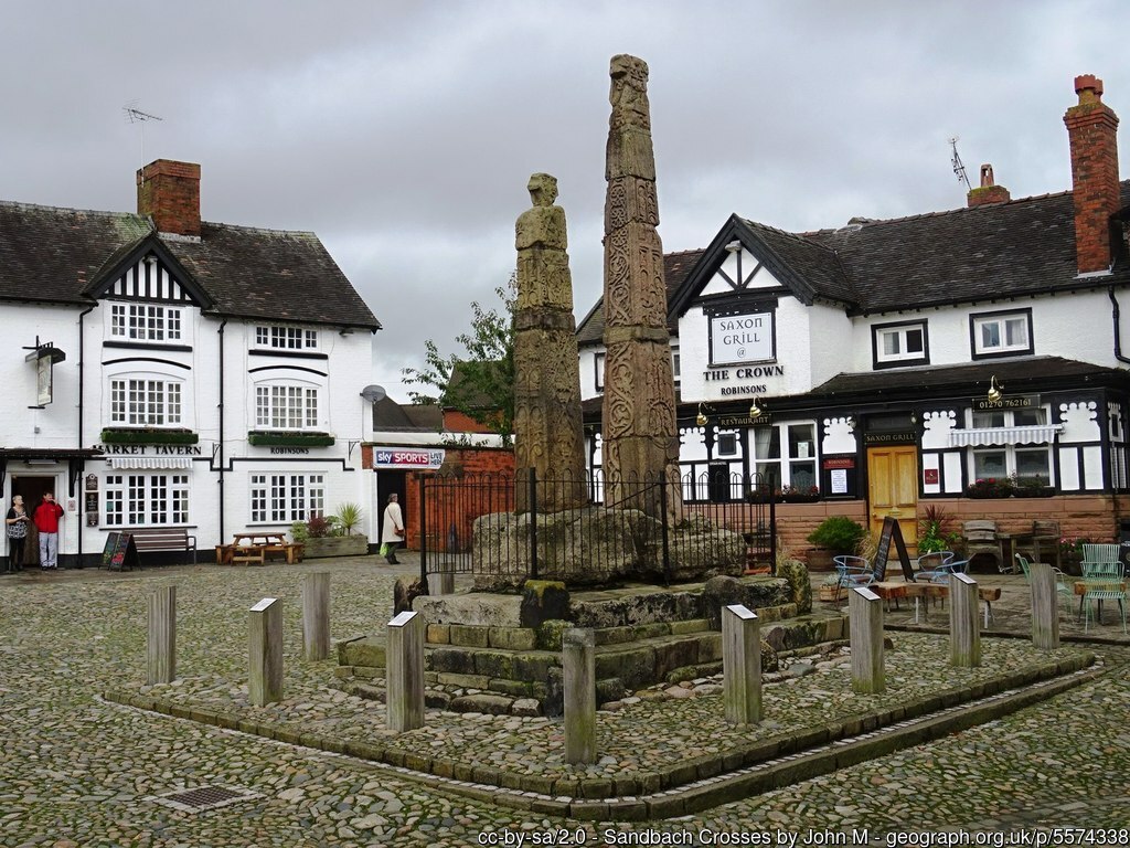
Sandbach Crosses
Knutsford is a prosperous town lying to the south of Altrincham. To its north is the historic estate of Tatton Park (NT). Tatton Hall is an 18th-century country house. Tatton Old Hall is the original 15th-century manor house. Around them are gardens and a deer park.
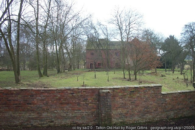
Tatton Old Hall
East of Knutsford is Wilmslow, well known for its celebrity residents. At Styal is Quarry Bank Mill (NT), one of the best preserved textile factories of the Industrial Revolution.
Alderley Edge is a village known for its affluence and its many historic buildings. Chorley Old Hall is the oldest surviving manor house in Cheshire. The village takes its name from The Edge (NT), a steep and thickly wooded sandstone ridge which overlooks the Plain. The Edge is steeped in legend and made famous as the location for Alan Garner’s children’s fastasy novels The Weirdstone of Brisingamen and The Moon of Gomrath. Nether Alderley Mill (NT) is a 16th-century working watermill.
Macclesfield stands on the the edge of the Cheshire Plain with the Macclesfield Forest in the Peak District to its east. The town is famous for its once thriving silk industry. North of Macclesfield is Prestbury, a wealthy commuter village with many historic buildings.
To the west of Macclesfield is the Jodrell Bank Observatory, famous for its 250 ft steerable radio telescope and now a UNESCO World Heritage Site. The town of Congleton stands on the River Dane close to the Staffordshire border. Nearby is the iconic Tudor manor house of Little Moreton Hall (NT).
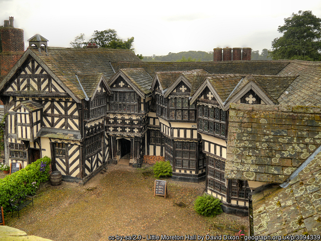
Little Moreton Hall
The Cloud (NT) stands on the border with Staffordshire, with extensive views from its heath-covered summit. South along the border, the village of Mow Cop lies on Mow Cop Hill on top of which is the 18th-century folly Mow Cop Castle (NT). The village, the hill and the castle all straddle the Cheshire – Staffordshire border.

Mow Cop Castle from the Cheshire side
It is thought that Cheshire was created by Edward the Elder around 920, although the earliest known recording of the name, as ‘Legeceasterscir’, is from the Anglo-Saxon chronicle in 980. This version of the name was derived from the then-name for Chester, meaning ‘city of the legions’. By the time of the Domesday Book, the county is recorded as having the name Cestrescir (Chestershire), again derived from the name for Chester at the time. William I created a new Earldom of Chester. Hugh d’Avranches, the first Earl, ruled almost autonomously and with the full authority of the King. Cheshire was therefore declared a County palatine, a title it still holds today.
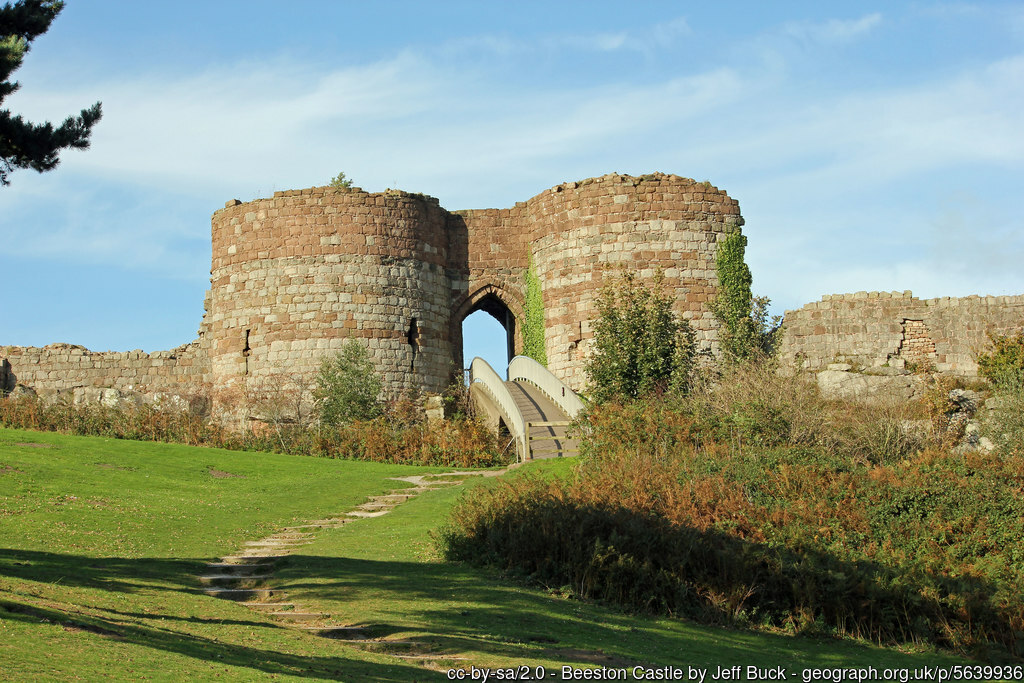
Beeston Castle
The county continued to be ruled and administered by Norman earls until the 7th Earl, John, died without a male heir in 1237. King Henry III took back the title, passing it to his son, Prince Edward – later King Edward I. Since this time the eldest son of all English monarchs has held the title of Earl of Chester. At the time of Domesday the county included two hundreds, Atiscross and Exestan, that later became parts of Flintshire and Denbighshire under the Statute of Rhuddlan 1282.
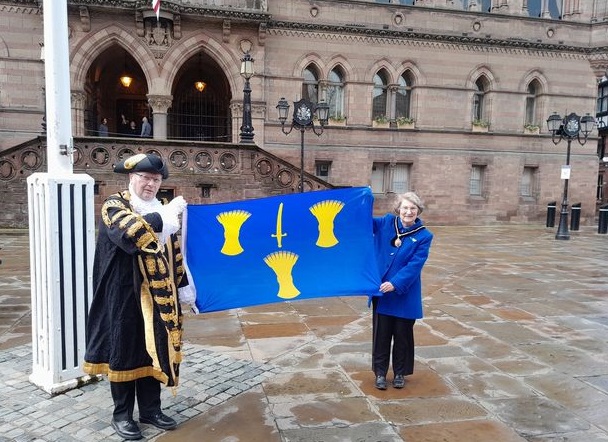
The Lord Mayor of Chester with the Cheshire flag outside the Town Hall on Cheshire Day 30th March 2023
The Cheshire flag consists of three golden sheaves of wheat and a golden blade on a blue background. The design has been associated with the Earldom of Chester since the 12th century.