
Kent Day is celebrated on 26th May, the feast day of St Augustine. In honour of the day we present our portrait of the county and a Map of Kent.
Kent is a maritime county at the south-easternmost point of Great Britain, known as the “Garden of England”. Kent is a county more full of history than any other. Kent’s name is also the oldest. It derives from the Cantii, an ancient British tribe known to the Romans long before Caesar. Kent was a British kingdom before the Romans came and after them it soon became a Jutish kingdom. It could almost still be considered a small country, based on the richness of its heritage, the beauty of its landscapes and the diversity of its settlements and economic activities.
Kent’s southern border with Sussex runs through the deeply ridged and folded countryside of the High Weald. The high land and ridges is formed from sandstone. The lower land between ridges is the result of softer clays which have been more easily eroded. The result is a mediæval landscape of wooded, rolling hills studded with sandstone outcrops; small, irregular-shaped fields; scattered farmsteads; and ancient routeways.
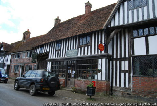
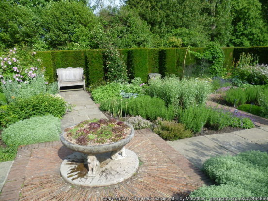
On the High Weald, in the west of Kent, stands the 13th-century Hever Castle, the childhood home of Anne Boleyn and later owned by Anne of Cleves. The nearby village of Chiddingstone is described by the National Trust as ” the most perfect surviving example of a Tudor village in the county”. Chiddingstone Castle dates from the early 19th century with elements of earlier buildings. To the east is the Georgian spa town of Royal Tunbridge Wells. The border with Sussex is marked by a flagstone outside the church of King Charles the Martyr. Cranbrook is an ancient market town, once a centre of the Wealden cloth industry. Union Mill (1814) is a working windmill. Nearby Sissinghurst Castle is now a romantic ruin. Around it is the famous Sissinghurst Castle Garden (NT), created in the 1930s by Vita Sackville-West and her husband Harold Nicolson. The former port town of Tenterden stands on the eastern edge of the High Weald overlooking the valley of the River Rother.
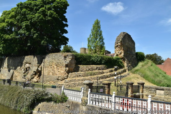
The Low Weald is a broad, low-lying clay vale which largely wraps around the northern and western edges of the High Weald. It is predominantly agricultural, supporting mainly pastoral farming owing to heavy clay soils. It has many densely wooded areas. In the west of the county, on the River Eden, is Edenbridge, once a centre of the Wealden iron industry. The town has many mediæval timber buildings. The Medway rises on the High Weald and flows through the biggest town in the Low Weald, Tonbridge. Tonbridge stands on a spur of higher land where the marshy River Medway could be more easily forded. Tonbridge Castle was built here in the 11th century by Richard Fitz Gilbert. Tonbridge School was established in 1552. Paddock Wood developed as a centre of the local hops industry and remains one. The village of Hamstreet lies at the eastern end of the Low Weald, with the flat landscape of Romney Marsh beyond.
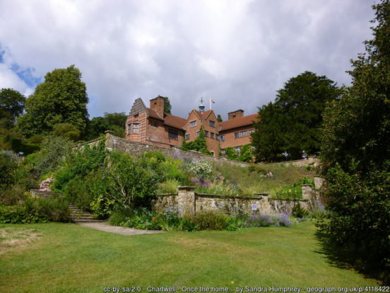
Wrapping around the Low Weald is the Greensand Ridge, an extensive, prominent mixed greensand/sandstone escarpment. Several of the major towns of Kent lie along the ridge. It also forms a transport corridor with major road and rail routes running along it. The ridge enters Kent around the town of Westerham. South of the town is Chartwell Manor (NT), Churchill’s home from 1922 until his death. Sevenoaks was first recorded in the 13th century. It developed around Knole House (NT), built in the 15th century as a palace for the Archbishop of Canterbury. The house sits in Knole Park (NT), a 1,000-acre deer park. Sevenoaks School, founded in 1432, is the oldest secular school in England. To the south, the mediæval moated manor house of Ightham Mote (NT) was described by Pevsner as “the most complete small mediæval manor house in the country”.
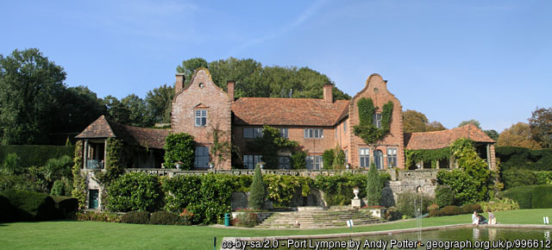
Maidstone lies where the Medway cuts through the Greensand Ridge. Historically, the river carried much of the town’s trade as the centre of agricultural Kent. Leeds Castle was a favourite residence of Edward I. The present building dates mostly from the 19th century and is built on islands in a lake formed by the River Len. Ashford, on the River Great Stour, has become a key transport hub. Its agricultural market is one of the most important in the county. At its south-eastern extreme, the Greensand Ridge forms a notable scarp, formerly a sea cliff, on which lies the village of Lympne, overlooking the Romney Marsh. The Port Lympne Wild Animal Park incorporates the early-20th-century Port Lympne Mansion and its landscaped gardens designed by architect Sir Herbert Baker.
The Greensand Ridge meets the sea in a short coastal stretch which extends from Folkestone to Hythe. From the beginning of the railway age, Folkestone developed from a small fishing community to be both a passenger port and as a high-class seaside resort. Hythe is beside a broad bay, although silting removed its harbour hundreds of years ago. The town has mediæval and Georgian buildings, an Anglo-Saxon / Norman church and seafront promenade.
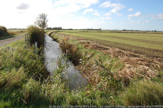
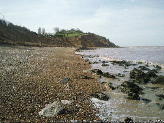
Below the Weald, in the far south-east of Kent, lies Romney Marsh, a sparsely populated wetland area. Criss-crossed with numerous waterways, the Marsh has over time sustained a gradual level of reclamation, both through natural causes and by human intervention. It covers about 100 square miles. In previous centuries, its isolation made it a notorious haunt of smugglers. The Marsh is famous for its long-wool “Romney” sheep. New Romney grew as a sea port, with the harbour adjacent to the church, but is now more than a mile from the sea.
To the north of the Greensand Ridge, the North Downs stretch across Kent, from south of Biggin Hill in the west to the White Cliffs of Dover in the east. The Kent section is also know as the Kent Downs. The county top, Betsom’s Hill, lies on the Kent Downs, close to the Surrey border. The Kent Downs have a steep south-facing scarp slope and a more gentle north-facing dip slope. Their southern boundary is defined by the low-lying Vale of Holmesdale at the foot of the escarpment, separating it from the Greensand Ridge. The ridge of the North Downs is intersected by the valleys of a series of rivers: the Darent, Medway and Stour which drain much of the Weald. Along the Darent valley is the village of Lullingstone. Lullingstone Roman Villa contains a Romano-Christian chapel, displaying some of the earliest evidence of Christianity in Britain. Lullingstone Castle dates from 1497. The surrounding deer park is renowned for its collection of ancient trees.
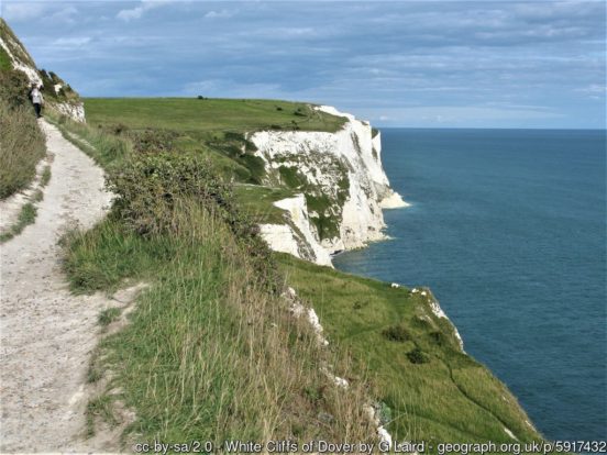
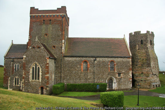
The White Cliffs of Dover spread for about eight miles along the Kentish coast, with the ancient and modern port of Dover crammed into a gap in the cliffs. The cliff face, which reaches up to 350 feet, owes its striking façade to its composition of chalk accentuated by streaks of black flint. Dover has since ancient days been the major conduit for traffic across the narrow seas betwixt Britain and Europe. The Roman’s named the town Dubris. Above the town, on the Eastern Heights, is Dover Castle, founded in the 11th century and described as the “Key to England” due to its defensive significance throughout history. The Pharos Roman lighthouse still stands in the castle grounds. On the Western Heights are a series of 18th- and 19th-century forts, strong points and ditches, including The Citadel and Drop Redoubt. The area is now a nature reserve.
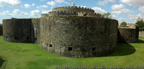
Between the North Downs and the Thames Estuary is the North Kent Plain. The area is essentially open, low and gently undulating land. It is a very productive arable land, with traditional orchards, soft fruits and other horticultural crops. At its south-east, north of Dover, is the quiet seaside resort of Deal. Its finest building is Deal Castle, commissioned by King Henry VIII and designed with an attractive rose floor plan. Once a major port, Sandwich is now two miles from the sea, its historic centre preserved but its historic role lost as the sea has retreated.
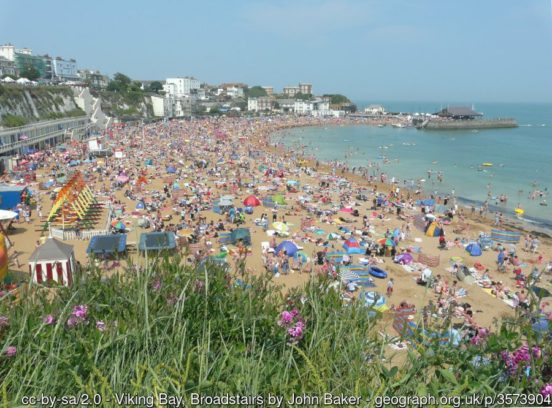
The Isle of Thanet, long since connected to the mainland, lies in the north-east tip of Kent. Long before Ramsgate became a great seaside town in the 19th century it was a busy port and remains so. Broadstairs is known as the “jewel in Thanet’s crown”. Margate has been a leading seaside resort for at least 250 years. West along the Thames Estuary is Herne Bay, a seaside resort which rose to prominence in the early 19th century after the building of the pleasure pier and promenade. Whitstable is famous for its oysters, which have been collected in the area since at least Roman times.
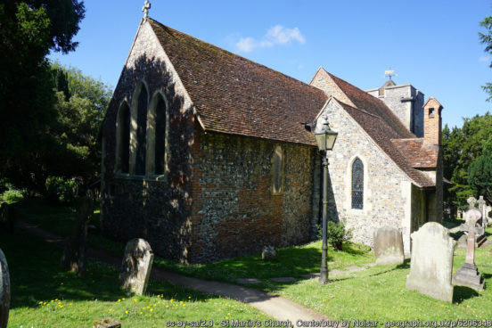
Five miles south of Whitstable, on the River Stour, is the historic cathedral city of Canterbury. Canterbury stood before the Romans came in the 1st century AD, and since then it has been a Roman town, then the capital of the Kingdom of Kent, a major mediæval town and now a modest provincial city. After Kent accepted Christianity in 597, St Augustine founded an episcopal see in the city and became the first Archbishop of Canterbury. The cathedral was completely rebuilt from 1070 to 1077 and developed in ensuing centuries. In 1170, Thomas Becket, then Archbishop, was murdered in Canterbury Cathedral and this led to the cathedral becoming a popular place of pilgrimage. Many historical structures remain in the city, including a city wall founded in Roman times, the ruins of St Augustine’s Abbey and a Norman castle. The 6th-century St Martin’s Church is the oldest church in Britain still in use as a church. It was originally the private chapel of Queen Bertha of Kent, Æthelberht’s Christian Frankish Queen.
Faversham is a market town which lies next to the Swale, the strip of sea separating mainland Kent from the Isle of Sheppey. There has been a settlement at Faversham since pre-Roman times, next to the ancient sea port on Faversham Creek. The town was favoured by King Stephen who established Faversham Abbey. Faversham Market dates back over 900 years, the oldest street market in Kent. Shepherd Neame Brewery, founded in 1698, claims to be the oldest in Britain. Sittingbourne, in a creek off the Swale, developed as a port from which Kentish produce was transported to the London markets. It had a long history of paper manufacture, growing to become the the largest producer of newsprint in the world. The last paper mill closed in 2006.
The Isle of Sheppey lies off the Coast opposite Sittingbourne. The island’s main towns are Sheerness and Minster. The island, like much of north Kent, comprises London Clay and is a plentiful source of fossils. The ground is mainly low-lying, but at The Mount near Minster rises to 250 feet above sea level.
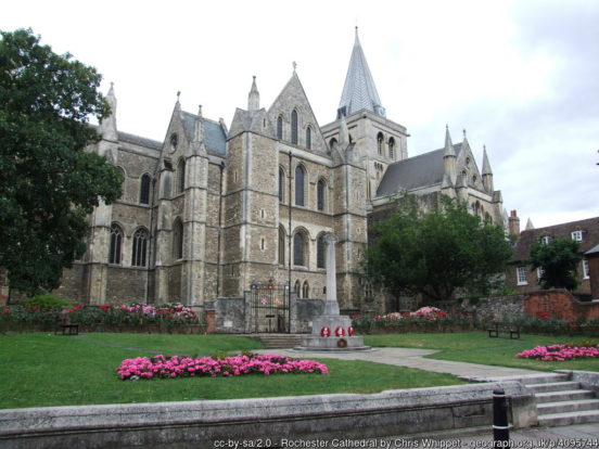
Rochester is at the lowest bridging point of the River Medway. The city is marked by two grand edifices; Rochester Cathedral and Rochester Castle. A great deal of history is found in these streets; Romans, Anglo-Saxon, Mediæval and modern. Strood stands on the north-west bank of the River Medway, opposite to Rochester. Strood’s history has been dominated by the river, the bridges and the road and rail links they carried. It is now a mainly residential suburb of Rochester, and a commuter town for London. Upnor Castle, an Elizabethan artillery fort, lies on the Medway north of the town.
In 1568 Queen Elizabeth I established the Royal Dockyard on the east bank of the Medway. Chatham, Brompton and Gillingham are all ancient settlements which grew around the dockyard and the 19th-century forts built to provide it with a defensive shield. The Dockyard closed in 1984, but the remaining major naval buildings are an attraction for a flourishing tourist industry. Rainham grew from a small village south of the Medway estuary to a residential town with the arrival of the railway in 1858.
The Hoo Peninsula separates the Medway and Thames estuaries. It is dominated by a line of sand and clay hills. Surrounding these are the North Kent Marshes, a major habitat for wetland birds. Cooling Castle is a 14th-century quadrangular castle built by the Cobham family to guard against French raids into the Thames Estuary. The strategic location of the Hoo peninsula has made it home to several power stations and oil refineries, especially at its farthest extent, on the Isle of Grain.
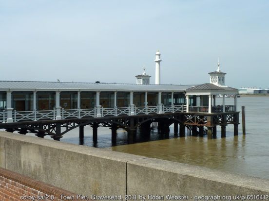
The North Kent Marshes stretch east from Hoo along the Thames estuary to Gravesend. Because of its geographical position Gravesend has always had an important role to play in the history and communications of south-eastern Britain. The Town Pier is the world’s oldest surviving cast iron pier, built in 1834. Windmill Hill offers extensive views across the Thames, and was a popular spot for Victorian visitors.
Dartford is situated in a valley through which the River Darent flows, and where the old road from London to Dover crossed: hence the name, from Darent ford. Dartford became a market town in the Middle Ages. Today it is principally a commuter town. During the Middle Ages Dartford was an important waypoint for pilgrims and travellers on the way to Canterbury and Europe, and various religious orders established themselves in the area. The Knights Hospitallers of the Order of Saint John of Jerusalem established a commandery at Sutton-on-Hone in 1199. The remains of its 13th-century chapel forms St John’s Jerusalem (NT).
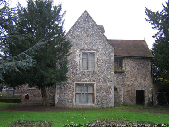
The north-west of Kent lies in the metropolitan conurbation, containing a great variety of townscapes. Orpington stands at the edge of the conurbation. The Priory is a 13th-century mediæval hall house, surrounded by Italianate and Arts & Crafts style formal gardens. Bromley was a market town which grew with the arrival of the railway. Its famous son H.G. Wells was born on the High Street in 1866. Sidcup is a fashionable suburb, with large Victorian and Edwardian properties alongside typical 1930s suburbia. Its many parks and open spaces hint at the great estates and large homes which once stood in the area.
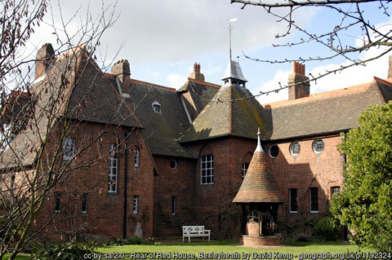
Into the 19th century, Bexleyheath was an area of scrub-land bordering Watling Street. In 1766 Sir John Boyd had the Palladian mansion Danson House built. The surrounded parkland now forms Danson Park. Red House is a significant Arts and Crafts building, co-designed in 1859 by the architect Philip Webb and the designer William Morris. It served as a family home for Morris.
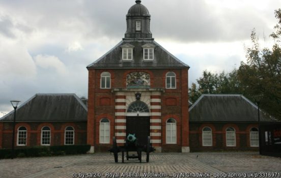
Woolwich is a river crossing point, with the Woolwich Ferry and the Woolwich foot tunnels. Woolwich was a small Kent village which grew to become a leading military and industrial town. It was home to the Woolwich Dockyard, the Royal Arsenal, the Royal Military Academy and the Royal Horse Artillery. Arsenal Football Club was founded in 1886 by workers at the Royal Arsenal – the club were initially known as Dial Square, then Royal Arsenal and then became Woolwich Arsenal in 1891.
The junction of Rock Hill and Sydenham Hill Road in Upper Sydenham forms the westernmost point of Kent. The border with Surrey runs north up Sydenham Hill Road with views out across metropolitan Surrey. Beckenham was, until the coming of the railway in 1857, a small village, with most of its land being rural and private parkland. John Barwell Cator and his family began the leasing and selling of land for the building of villas which led to a rapid increase in population. Lewisham was a small village until the development of passenger railways in the 19th century.
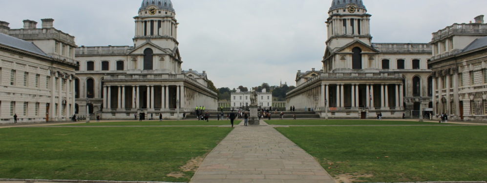
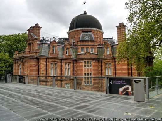
In the north-west of Kent, on the Thames, lies the world famous town of Greenwich. Its rise to fame began when the Palace of Placentia was built here by Humphrey, Duke of Gloucester in 1443. The palace was the birthplace of many Tudors, including Henry VIII and Elizabeth I. The Old Royal Naval College is the architectural centrepiece of the Maritime Greenwich UNESCO World Heritage Site. The buildings, originally constructed to serve as the Royal Hospital for Seamen, was designed by Christopher Wren and completed in 1712. The Cutty Sark and Gipsy Moth IV are sited on the river front. The National Maritime Museum is housed in buildings forming another symmetrical group and grand arcade around the Queen’s House, designed by Inigo Jones. Greenwich Park includes the former Royal Observatory, the crosshairs of whose telescope define the prime meridian of the world.
In 1066 the Normans landed nearby in Sussex. The men of Kent according to legend raised the fyrd to oppose William independently and made a separate peace without clash of arms. This legend is the origin of the county motto Invicta, meaning “unconquered”. Kent played a major role in several of England’s most notable rebellions, including the Peasants’ Revolt of 1381, led by Wat Tyler, Jack Cade’s Kent rebellion of 1450, and Wyatt’s Rebellion of 1554 against Queen Mary.

The Kent Flag features the white horse of Kent (supposedly based on that of Horsa, the Jute) on a red background. It is sometimes referred to as the Invicta Flag.
3 thoughts on “Kent Day – 26th May”
As a man of Kent or Kentish man
I can never remember which , I enjoyed the post
I am a Man of Kent born and brought up in Cranbrook but the last 40 years I have lived and worked in West Yorkshire. With Yorkshire Day – 1st August -m fast approaching local news media will be full of pieces praising the Yorkshire National Anthem – a folk song written in Yorkshire to a locally composed tune and called Ilkley moor B’aht ‘at. What few hereabouts seem to know is that it is a hymn tune called Cranbrook; it was written by Thomas Clark of Canterbury to celebrate his longstanding friendship with a prominent Cranbrook family. I have written a booklet explaingin the background which I send to the authors of the Yorkshire myth and if anyone in Kent who wants to see it i will gladly send a copy if they give me a name and address at florence.annie.outlook.com
The reference to Chatham Dockyard is rather poor and should have been much more prominent. Up until the 19th century it was the premier English dockyard with HMS Victory built there and many other Chatham ships fought in the Battle of Trafalgar. It was only the lack of deep water that allowed Portsmouth to take over.
Also no mention of Chatham being the home of the Royal Engineers.