
Saturday 1st May 2021 is Staffordshire Day – the anniversary of the founding of Josiah Wedgewood and Sons. We present our portrait of the county.
Staffordshire is an inland county in the English Midlands. The county provides great contrasts, from the wild moorlands of the north-east to the urban landscapes of the south-west. The River Trent rises on Biddulph Moor near the Cheshire border and then flows south-eastward across the county before turning north-eastward to form the boundary with Derbyshire for several miles. Many of the county’s towns lie on or close to the Trent. The county can be divided into five physical regions.
The far north-east of the county lies in the southern end and foothills of the Pennines, much of it lying in the Peak District National Park. The area, composed of grit and limestone, is known as the Staffordshire Moorlands. Dovedale and Beresford Dale, on the border with Derbyshire, are renowned for their beauty. The Manifold valley, once famous for the mining of copper and lead, is now renowned for its beauty. Thor’s Cave, a natural cavern in a limestone crag, is a popular landmark. Ilam Park (NT), a country park with a 19th-century hall, sits across both banks of the River Manifold.
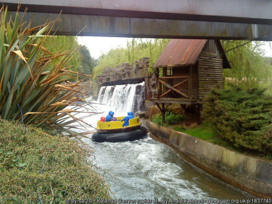
Buddulph lies close to the Cheshire border, near the Mow Cop Ridge and folly, shared with Cheshire. Biddulph Grange (NT) is a grand country house, now private apartments. Biddulph Grange Garden (NT) were developed by James Bateman (1811–1897), the accomplished horticulturist and landowner, to display specimens from Bateman’s extensive and wide-ranging collection of plants. The pretty market town of Leek is known as the “Queen of the Moorlands”. Cheadle is an historic market town dating back to Anglo-Saxon times. The 200 feet spire of St Giles’ Catholic Church dominates Cheadle’s skyline. Known as “Pugin’s Gem”, it is considered one of the finest Victorian churches in Britain. Nearby is Alton Towers, a visitor attraction since its grounds first opened to the public in 1860. It is now the UK’s biggest and best-known theme park.
South of the moorlands lie the northern Staffordshire coalfields, consisting of sandstones, clays, and shales interspersed with coal seams. This part of Staffordshire has been a centre for pottery since Roman times. Ceramic production in the area took off in the 17th century due to the local availability of clay, salt, lead and coal. The region became known as “The Potteries”. Hundreds of companies produced decorative or industrial ceramic items, based around the six towns of Hanley, Stoke-upon-Trent, Burslem, Fenton, Longton and Tunstall. These were formed into a single borough, later city, under the name “Stoke-on-Trent’ in 1910 but retain their separate identities.
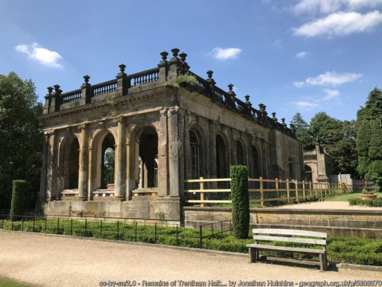
Trentham Hall, south of Hanley, was a great stately home until its demolition in 1912. The house was designed by Charles Barry, while he was working on the rebuild of the Palace of Westminster. Only the Grand Entrance and the Orangery remain. Trentham Gardens (NT), the estate’s formal Italian gardens, have undergone a major restoration.
Kidsgrove is a former mining town north of The Potteries. Newcastle-under-Lyme is an old market town west of The Potteries. Whitmore Hall, the home of the Cavenagh-Mainwaring family, at Whitmore, south of Newcastle, is a fine example of a small Carolean style manor house.
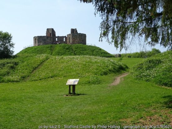
South of The Potteries is the central agricultural belt, an area of sandstones and marls. The town of Stone, lying on the Trent and on the ancient main roads, has long been of importance as a hub of communication. At one time it was capital of Mercia and, later, the site of Stone Priory. In the centre of the county is Stafford with its ruined Norman castle and 18th-century Shire Hall. Shugborough Hall (NT) is a stately home in Great Haywood, east of Stafford, long the seat of the Lords Anson and Earls of Lichfield.
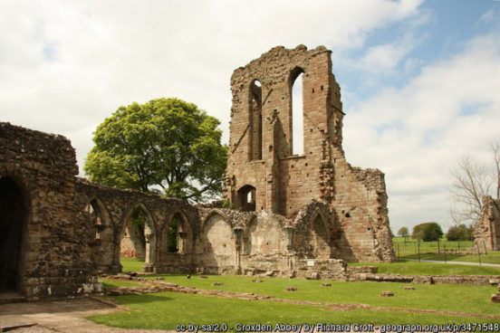
Uttoxeter is a small market town close to the River Dove, the border with Derbyshire. The famous Uttoxeter Racecourse is here. Blithfield Hall is an Elizabethan private country house near Uttoxeter. The ruins of Croxden Abbey stand in Croxden north of the town. Further south-east, where the Trent forms the border with Derbyshire, lies Burton-on-Trent, historically the heart of the brewing industry, a continuing tradition. Tutbury Castle is a ruined mediæval castle on the Derbyshire border a few miles north of Burton. Mary, Queen of Scots was a prisoner.
Weston Park is a country house in Weston-under-Lizard set in more than 1,000 acres of park landscaped by Capability Brown. The house and park lie in the very west of the county, the border with Shropshire passing through the south of the park.
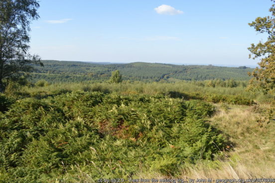
South-east from Stafford stretches Cannock Chase. A former royal forest, the Chase comprises a mixture of natural deciduous woodland, coniferous plantations, open heathland and the remains of early industry and coal mining. The historic market town of Rugeley stands on the north-eastern edge of the Chase. The former mining town of Hednesford lies to the south-west of Cannock Chase with the town of Cannock itself to the south of it. The former mining town of Burntwood lies to the south-east, also along the edge of Chase.
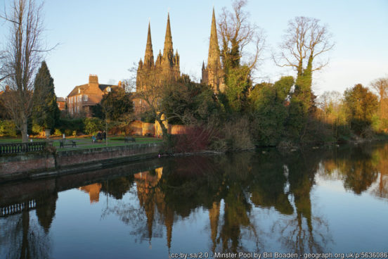
At the south of the Chase is Lichfield, one of the smaller cities of the land. Restrained in its houses and shops, the city has a large and ornate three-spired mediæval cathedral. Pevsner believed that Lichfield Cathedral had the finest setting of any English Cathedral, viewed across the Minster Pool. The bishopric is one of the oldest in Britain. In the far south-east of the county, on the River Tame, is Tamworth, one time capital of the Anglo-Saxon Kingdom of Mercia. Drayton Manor Theme Park lies south-west of the town.
The far south-west of Staffordshire is heavily urbanised where the industrial towns of the Black Country have grown over the rich coal seams which drove the industrial revolution in these parts. The heavy industry of the nineteenth century gathered here and in nearby Birmingham, so that all have grown into a giant conurbation of communities.
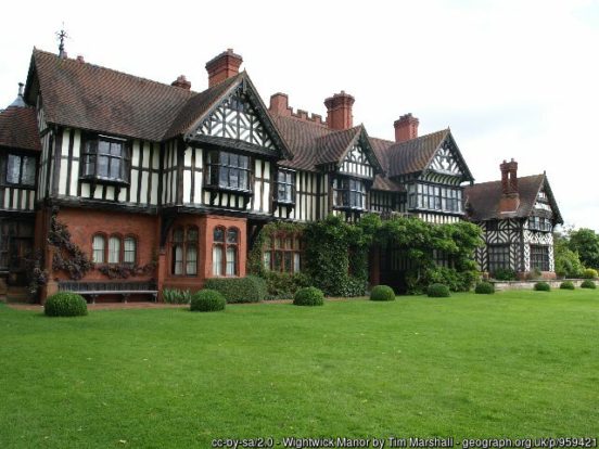
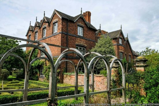
Wolverhampton lies at the north-west of the conurbation. The city became a major industrial centre during the Industrial Revolution. The major industries today are in the engineering and service sectors. Wightwick Manor is a timber-framed Victorian manor house on Wightwick Bank. It is one of only a few surviving examples of a house built and furnished under the influence of the Arts and Crafts movement. The 17th-century Moseley Old Hall (NT), at Fordhouses north of the city, is famous as one of the resting places of King Charles II during his escape to France following defeat at the Battle of Worcester in 1651. Bilston, south-east of Wolverhampton, is a former industrial town. South-east of Bilston is Wednesbury, a market town on the Tame with a long history before the growth of the Black Country. Heavy industry has come and gone but the traditional market is still a feature of the bustling centre.
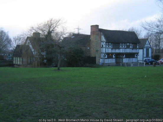
West Bromwich, south-east of Wednesbury, developed rapidly in the 19th-century after coal deposits were discovered in the area. West Bromwich Albion FC was founded in 1878 and, in 1888, became one of the twelve founder members of the Football League (as did Wolverhampton Wanderers and Stoke City). West Bromwich Manor House on Hall Green Road dates from the late 13th-century.
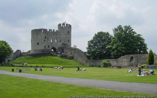
South of West Bromwich, against the border with Warwickshire are Smethwick, a former industrial town, and, in contrast, Harborne, a prosperous Victorian suburb. Rowley Regis lies south-west of Harborne, separated from it by the Oldbury area of Worcestershire. The town grew significantly between the wars with housing developments on a large-scale. Although Dudley, to the north of Rowley Regis, lies in a detached part of Worcestershire, Dudley Castle, which stands in a noble ruin above the town, is in Staffordshire. Dudley Zoo is located in the castle grounds. Walsall lies to the east of Wolverhampton and is known as ‘the town of a hundred trades’. It has historically been a manufacturing town, and was particularly known for leatherwork – Walsall FC are known as “The Saddlers”.
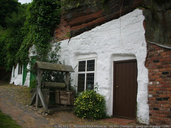
To the west of the Black Country conurbation is an area of the county which combines rich agricultural land with suburban development. This area, which includes the small towns of Wombourne and Kinver, lies in the headwaters of the River Stour, a tributary of the River Severn. There are notable rock or cave houses on Kinver Edge (NT), carved from the sandstone, some inhabited as late as the 1960s. The River Severn flows through the very far south-west of the county, at Upper Arley.
Traces of Neolithic and Bronze Age settlements remain in the north-east of the county, where there are long, low Neolithic burial mounds. There are Iron Age hill forts at Castle Ring on Cannock Chase and Bury Ring near Stafford.
The Romans built roads through the forests that covered the area which became Staffordshire, including Watling Street and Ryknield Street, intersecting near Lichfield. Roman settlements developed along those roads, including Letocetum and Pennocrucium. From the 7th until the 9th century the area was the centre of the Anglo-Saxon kingdom of Mercia. Tamworth was the kingdom’s capital, Lichfield became its religious centre. The county probably first came into being in the decade after the year 913; that being the date at which Stafford became the new capital of Mercia under Queen Æthelflæd. The county is first mentioned by name in the Anglo-Saxon Chronicle in 1016. Domesday Book (1086) recorded a sparsely populated and poor area.
Coal and iron were mined on the upper River Trent and around Cannock Chase from the 13th century, though they did not achieve real importance until the late 18th century. The long-established pottery industry in the north-west became renowned during the 18th century, particularly through the efforts of Josiah Wedgwood. The brewing industry of Burton upon Trent acquired recognition in the 19th century. By the mid-19th century the Black Country had become a major industrial area, with numerous coal mines and steel mills. By the end of the 20th century coal mining had ceased and heavy industry declined. Most of Staffordshire is still agricultural, with dairy farming being particularly important. Metalworking and engineering continue around Stoke-on-Trent, where the pottery and glass industries also remain important. Stafford has light engineering and shoe manufacture. Leek produces silk and rayon. Burton upon Trent remains famous for its beer.
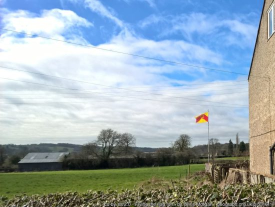
The Staffordshire Knot originated as a heraldic badge of the Stafford family but has become a symbol closely associated with the county. It appears in the badges and logos of many county organisations and on the Staffordshire Flag.