
Yorkshire Day, held annually on 1 August, was created by the Yorkshire Ridings Society in 1975 as a celebration of the county. It has grown to become a huge event, both within the county and for Yorkshire men and women throughout the world. In celebration we present our portrait of the county and our Map of Yorkshire.
Yorkshire is a maritime county in the north of England, the largest county of them all by far. It stretches from the North Sea coast deep into and over the Pennine Mountains, and from the River Tees to the Humber and further south inland. It encompasses empty moorland and crowded conurbations, high fells and low plains. It is a county with a strong character and identity of its own.
Yorkshire can be broadly split into five major topographical areas. There is a close relationship between these areas and the underlying geology. The Pennine chain of hills in the west, dissected by the Yorkshire Dales, is of Carboniferous origin. The central lowlands (including the Vale of Mowbray, the Vale of York and the Humberhead Levels) are Permo-Triassic. The North York Moors in the north-east are Jurassic in age. The Yorkshire Wolds in the south-east are Cretaceous chalk uplands. In the far south-east is Holderness, the flat, broad triangular land caught between the sea and the Humber. The rivers of western and central Yorkshire drain into the River Ouse which reaches the North Sea via the Humber. In the far north, the River Tees flows eastwards through Teesdale and flows into the North Sea downstream of Middlesbrough. The smaller River Esk flows at the northern foot of the North York Moors to reach the sea at Whitby. The western Pennines are served by the River Ribble which drains westwards into the Irish Sea close to Lytham St Annes in Lancashire. The county top is Mickle Fell (2,585 feet) in the Pennines.
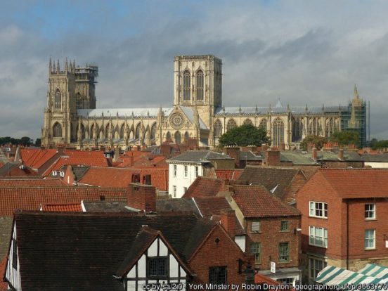
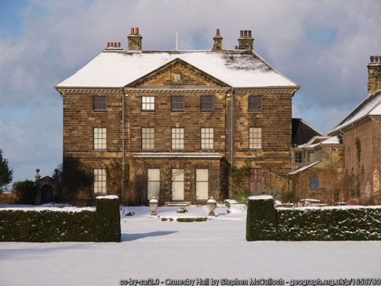
Yorkshire is divided into three ridings, whose boundaries meet at the walls of the ancient city of York. York is in the middle of the shire. It was a great city even in Roman times (the co-capital of Britannia). It is a delight of mediæval streets, and at its heart is its huge and delightful cathedral, York Minster, the seat of the Archbishop of York and headquarters of the Northern Province of the Church of England. York Castle is a fortified complex consisting of a sequence of castles, prisons, law courts and other buildings, which were built over the last nine centuries on the south side of the River Foss. The now-ruined keep of the medieval Norman castle is commonly referred to as Clifford’s Tower. The city also preserves several examples of medieval secular architecture, including the Merchant Adventurers’ Hall and the Guildhall. Fairfax House, a Georgian townhouse in Castlegate, has been restored and is a museum.
The East Riding
The East Riding lies along the coast of the North Sea and the Humber. The River Ouse forms the border with the West Riding. The Derwent valley forms the border with the North Riding, apart from the section between York and Stamford Bridge which follows the old Roman road between the two (A166), and closer to the sea where the border crosses the River Hertford floodplain before meeting the sea along the Filey Beck.
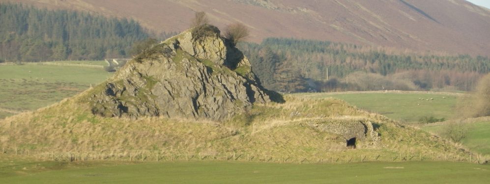
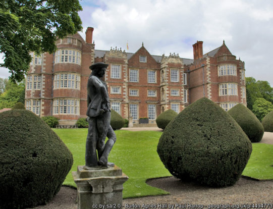
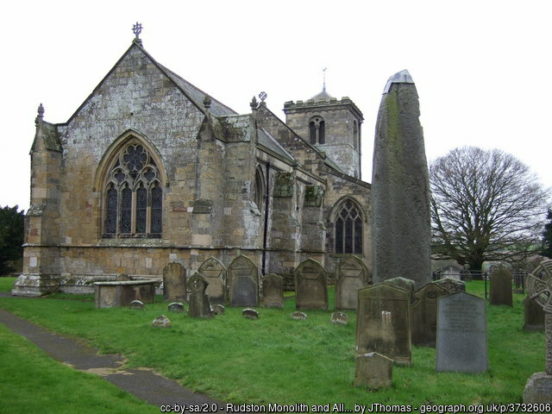
The Yorkshire Wolds form a broad crescent of rolling chalk hills and valleys, arcing from the coast at Flamborough westwards towards Norton-on-Derwent and then south to the Humber Bridge. Known as “The Capital of the Wolds’, the market town of Driffield lies close to their centre. The remains of Driffield Castle, a motte-and-bailey castle, sit at Moot Hill. To the east of Driffield is the village of Rudston. In the churchyard is the Rudston Monolith, at over 25 feet the tallest megalith in Great Britain. The nearby village of Burton Agnes has both an Elizabethan manor house, Burton Agnes Hall, and a Norman manor house, Burton Agnes Manor House.
To the north-west of Driffield is Sledmere House, seat of the Sykes family, the great pioneers of farming on the Wolds. The present house dates from the 18th century but was rebuilt after a fire in 1911. It containing Chippendale, Sheraton and French furnishings and many fine pictures, set within a park designed by Capability Brown. Sledmere itself is a fine example of an estate village. Nearby is Wharram Percy the best known deserted village site in Britain, whose excavation revolutionised knowledge of mediaeval villages.
The ancient market town of Beverley, famous for Beverley Minster and Beverley racecourse, lies on lower ground in the south of the Wolds. St Mary’s, at the other end of town from the cathedral-like Minster, is ‘one of the most beautiful (and famous) parish churches of England’ (Pevsner). Close by is the imposing brick-built North Bar (1409), still the official exit from the town. Two large central open spaces – Wednesday Market and Saturday Market – lend character to a place full of historic interest, one of the most charming in the country. The Skidby Windmill, south of Beverley, was opened in 1821 and is the last remaining working windmill north of the Humber.
In the west of the Wolds is Market Weighton. Each May the town celebrates Giant Community Day, a festival in a celebration of William Bradley, the tallest ever Briton. Pocklington, a small market town situated at the foot of the western side of the Wolds, has a skyline dominated by the 15th-century tower of All Saints church.
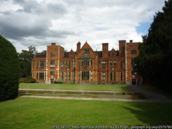
To the west of the Wolds, a large area of the East Riding lies in the Vale of York. The village of Stamford Bridge was established as a fort by the Romans at an ancient ford on the River Derwent. The Battle of Stamford Bridge on 25 September 1066 marked the end of the Viking era in Britain. From here, the Derwent flows south to meet the Ouse at Barmby on the Marsh and the border with North Riding follows the old Roman road to York. Those suburbs of York in the East Riding (outside the walls) include Fulford, Heslington and Badger Hill. Heslington Hall, part of the campus of the University of York, was originally constructed in 1568 but largely rebuild in the mid 19th-century in Victorian style.
The village of Escrick, south of York, sits at the southernmost limit of glaciation during the last ice age. When the ice retreated, a deposit known as a “terminal moraine” was left behind, in the form of a ridge. The Escrick Moraine marks the southern limit of the Vale of York and the northern limit of Humberhead Levels. The levels occupy the former Glacial Lake Humber. The market town of Howden lies at the south of this area, just north of the River Ouse. Work began on Howden Minster in the 12th-century, though it was not completed until the 15th-century.
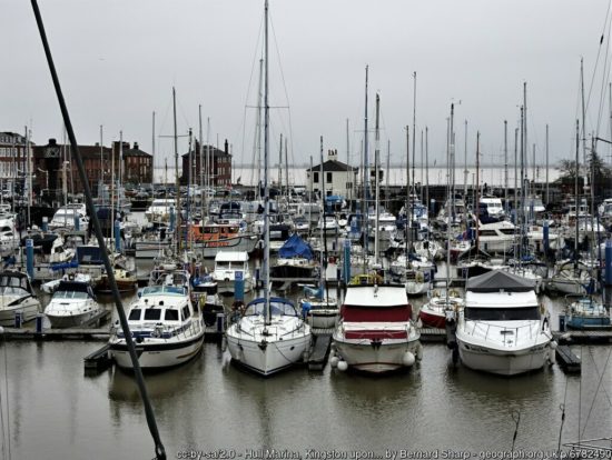
A few miles downstream from Howden, the Ouse meets the Trent and, from that point, the Humber estuary carries the waters of both rivers to the North Sea. The historic port of Kingston-upon-Hull, usually referred to as Hull, stands on the Humber where the River Hull enters it. Kingston-upon-Hull is one of Yorkshire’s great cities, by far the largest place in the Riding. Among its landmarks are the Holy Trinity Church, by area the largest parish church in England; Wilberforce House, in the mediaeval High St., birthplace of the politician, abolitionist and social reformer William Wilberforce (1759–1833); the Guildhall; City Hall; Ferens Art Gallery and Town Docks Museum.
The town of Hessle lies five miles west of Hull. The Hessle Feast is a celebration held every Whitsuntide. The Humber Bridge, opened in 1981, crosses from Yorkshire (just west of Hessle) over to Barton-upon-Humber in Lincolnshire. Downstream from Hull, near the village of Paull, is the Fort Paull gun battery. There has been a fort on the site since 1542. The current fort is of pentagonal design and was built in 1861–4, one of the Palmerston Forts.
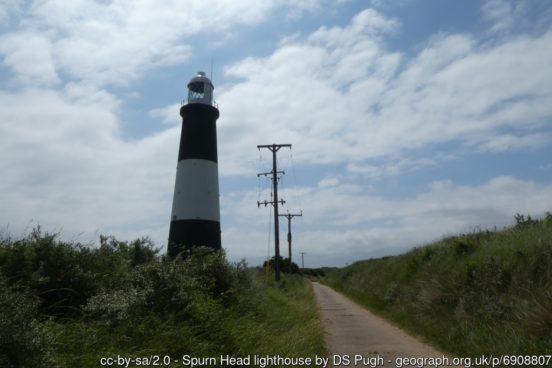
To the south-east of the Wolds lies Holderness, a flat, broad triangular land between the sea and the Humber. It comes towards a point and a narrow whip of land ending at Spurn Head. Holderness is subject to large-scale coastal erosion. Over 30 of its settlements have been lost to the sea in recent centuries. Burton Constable Hall is a large Elizabethan country house, with 18th- and 19th-century interiors, one of the grandest mansions in the Riding. St Augustine’s Church, Hedon is the most interesting specimen of early pointed architecture in Holderness and is commonly known as The King of Holderness. The 14th century St Patrick’s Church, Patrington is rated among the finest in the whole country by architectural writers.
The East Riding coast describes a smooth line along Holderness and a smooth sandy curve up to Flamborough Head. Withernsea, on Holderness, is a resort town whose attractions include the Withernsea Lighthouse, now with a museum dedicated to the local actress Kay Kendall. North along the coast is Hornsea, a small resort well known for pottery. Hornsea Mere is Yorkshire’s largest lake and a fine natural feature. North of Hornsea is Skipsea Castle, a Norman motte and bailey castle built around 1086 by Drogo de la Beuvrière, apparently on the remains of an Iron Age mound.
Further north is the major resort town of Bridlington. Bridlington Quay is the home of the tourist area and the harbour. Bridlington Spa opened in 1896 and has played host to the best known entertainers of many generations. Bridlington Priory is named after the Augustinian Priory on which it was built. Bridlington is also a minor sea-fishing port, known for shellfish. Near the town is Sewerby Hall, a Georgian country house set in 50 acres of landscaped gardens.
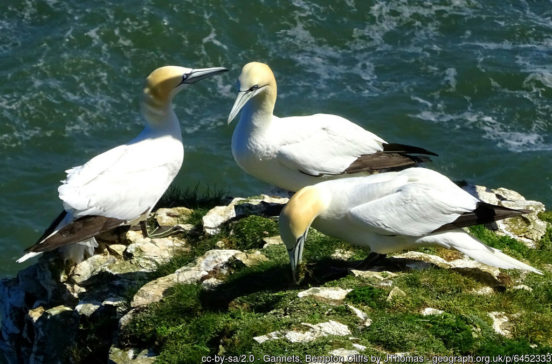
The Yorkshire Wolds meet the coast north of Bridlington, forming the spectacular cliffs of Flamborough Head. North of these are Bempton Cliffs, the only mainland breeding site of gannets in Great Britain, and Speeton Cliffs, overlooking Filey Bay. The Old Town of Filey lies in the East Riding, though the northern parts of the town lies across the Filey Beck in the North Riding.
To the north of the Wolds lies the Vale of Pickering, the valley of the Derwent, the south side of which lies in the East Riding. A string of villages lie along the A64 above the floodplain of the Derwent. These include Flixton, Staxton, Sherburn, Rillington and Scagglethorpe. Scampston Hall, lying north of the A64, was built in the late 1600s for William Hustler. The hall has two storeys of stuccoed orange-red brick with a slate roof and stuccoed brick chimney stacks. The small town of Norton-on-Derwent lies at the west end of the Vale, on the south bank of the Derwent, opposite Malton in the North Riding. From here the Derwent flows south-west into the Vale of York.
The North Riding
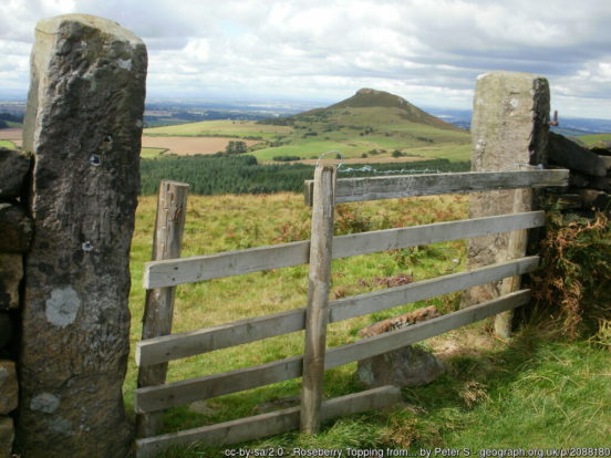
The North York Moors occupy a vast upland area in the east of the North Riding. This moorland is one of the largest expanses of heather moorland in the United Kingdom. The greater part of the moor has been declared a national park. The Cleveland Hills lie on the north-western edge of the North York Moors. The hills, which rise abruptly from the flat Tees Valley to the north, include distinctive landmarks such as the cone-shaped peak of Roseberry Topping.
The Hambleton Hills form the western edge of the North York Moors, separated from the moors by the valley of the River Rye. They are the eastern boundary of the low-lying Vale of Mowbray which they abut with a precipitous escarpment. The Tabular Hills are an east-west line of distinct hills on the southern boundary of the North York Moors, running from Scarborough in the east to Black Hambleton in the west. The name refers to their flat, tabular summits composed of hard Corallian limestone. They form the northern boundary of the Vale of Pickering. To the east the moors end at the impressive sea cliffs of the North Sea coast.
Scarborough, at the south end of the North Riding’s coast, is Yorkshire’s biggest seaside resort. The town has attracted visitors since the 17th century when the medicinal properties of its Spa waters first became known. The setting is spectacular. The fishing harbour and old town lie below the castle situated on the high cliff which separates the North and South bays. Prominent along the south shore are the huge Victorian Grand Hotel and the Spa with its famous ballroom and theatre.
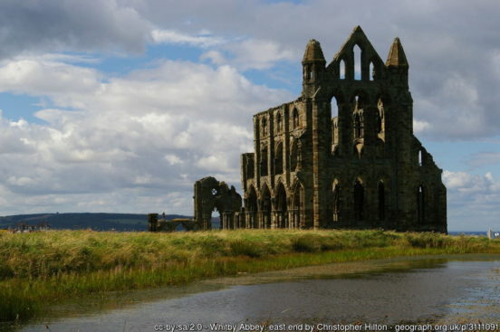
The small fishing village of Robin Hood’s Bay lies to the north of Scarborough. North of that is the ancient port town of Whitby, a tourist town since Georgian times, enhanced by its location surrounded by the North York Moors and by association with the horror novel Dracula. The old town comprises fishermen’s cottages in yards on the eastern side of the harbour. It was the home port of the explorer Captain James Cook. The holiday resort was laid out on the west cliff in Victorian times. From the fisher town rise 199 steps leading to the Abbey ruins and the unique Parish Church whose charming jumble of irregular pews and galleries face a three-decker pulpit – wood everywhere, as in a fishing-boat.
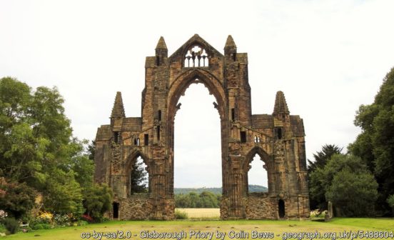
Staithes is a breath-takingly beautiful fishing village built in a deep cleft in the precipitous slopes where the hills reach the sea. To the north are the spectacular Boulby Cliffs, among the highest in England. Saltburn-by-the-Sea developed from the mid 19th-century around a small fishing hamlet. Redcar, just to the south of the Tees estuary, was a fishing town until the opening of the Middlesbrough to Redcar Railway in 1846, after which it prospered as a seaside town drawing tourists to its eight miles of sands that lead on to Saltburn-by-the-Sea. Redcar Racecourse opened in 1875. Guisborough is a market town on the northern slopes of the Cleveland Hills looking down toward the coast five miles away. The ruined Gisborough Priory dates to the 12th century.
The mouth of the Tees, at the very northern bounds of Yorkshire, is an industrial centre. Middlesbrough is a port and factory town that grew from nothing in the 19th-century but from which a small conurbation has grown. Its prodigious expansion in the 19th and early 20th centuries was based on heavy industry – iron and steel and chemicals – now replaced by lighter technologies, often IT-related. Landmarks are the Victorian Town Hall, the Museum of Modern Art and the Transporter Bridge, carrying a suspended travelling ‘car’, or ‘gondola’, across the river in 90 seconds. In the suburb of Ormesby is Ormesby Hall (NT), a predominantly 18th-century mansion house built in the Palladian style.
The market town of Thornaby-on-Tees lies on the Tees four miles west of Middlesbrough. The Church of St Peter ad Vincula (“St Peter in chains”) is of 12th-century origin. The unusual dedication is derived from the ancient Basilica of San Pietro in Vincoli in Rome. The neighbouring town of Ingleby Barwick was created from scratch in the 1970s as a private residential estate, though the name is that of the ancient township. The oldest part of the market town of Yarm, around the High Street, is situated in a loop of the Tees. The imposing 2,280 foot-long railway viaduct was built across the Tees between 1849 and 1851 for the Leeds Northern Railway Company.
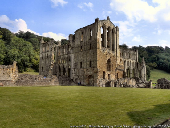
To the south of the North York Moors lies the Vale of Pickering, the low-lying plain drained by the River Derwent, the northern side of which lies in the North Riding. The landscape is rural with scattered villages and several small market towns. Helmsley lies on the River Rye as it leaves the moors. The remains of the mediæval Helmsley Castle tower over the town. The striking ruins of the Cistercian Rievaulx Abbey (EH) lie nearby. Pickering is an ancient market town at the foot of the Moors, overlooking the Vale to which it gives its name. Pickering Parish Church is known for its mediæval wall paintings. Pickering Castle is a mediæval motte-and-bailey castle. Malton lies on the north bank of the Derwent, with Norton-on-Derwent (in the East Riding) on the opposite bank. Malton is the local area’s commercial and retail centre. The town markets itself as “the Food Capital of Yorkshire”.
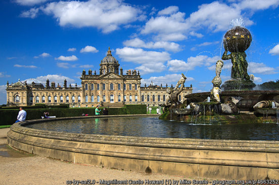
The Howardian Hills rise to the west of the Vale of Pickering separating it from the Vale of York. The hills are a unique and captivating landscape with its well-wooded rolling countryside, patchwork of arable and pasture fields and scenic villages. Much of the range is part of the Castle Howard Estate, owned by the Howard family, after which the hills are named. The hills are the setting for a number of fine country houses, whose parklands are an intrinsic part of the landscape. The finest is Castle Howard (18th Century), designed by the playwright, Vanbrugh – its great size and ornamental features a superb example of the Baroque style. It lies within extensive landscaped grounds with lakes, a temple and mausoleum. Castle Howard has been the home of the Carlisle branch of the Howard family for more than 300 years. Newburgh Priory is a Tudor building near Coxwold, with 40 acres of grounds including a water garden, walled garden, topiary yews and woodland walks. Hovingham Hall is a country house built in the Palladian style. Gilling Castle is a fortified manor house dating from the 14th-century. Nunnington Hall (NT) was first mentioned in the 13th-century though the present building was created in the 1680s.
The Vale of Mowbray is a stretch of low-lying land between the North York Moors and the Hambleton Hills to the east and the Yorkshire Dales to the west. To the north lie the Tees Valley lowlands and to the south the Vale of York. The Vale of Mowbray comprises fertile agricultural land used for crops and permanent grassland, though isolated pockets of woodland remain. The roads in the Vale are characteristically contained by low hedges with wide verges.
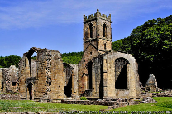
Northallerton is an affluent market town in the north of the Vale of Mowbray. Lying on the main route between Edinburgh and London, Northallerton became an important stopping point for coaches. East of the town is the 14th-century Mount Grace Priory (EH), the best preserved ruins among the nine houses of the Carthusian Order which existed in England in the Middle Ages and which were known as charterhouses. Thirsk, eight miles south of Northallerton, is a popular tourist destination close to the North York Moors and well known for its racecourse.
To the south of the Vale of Mowbray is the Vale of York. That part in the North Riding is an arable, low-lying landscape with small villages. The only sizable settlements are the market town of Easingwold, at the foot of Howardian Hills, and Haxby, close to York and today primarily a dormitory town. Beningbrough Hall (NT) is an imposing Georgian mansion containing one of the most fascinating Baroque interiors in the country. The house overlooks the Ouse north-west of York. Those suburbs of York in the North Riding (outside the walls) include Clifton, Rawcliffe, New Earswick, Huntingdon, Earswick, Layerthorpe, Heworth and Osbaldwick.
The western part of the North Riding is in the Pennines, with wild, often breath taking scenery. In the Lune Forest in Upper Teesdale, Mickle Fell stands at 2,591 feet, the highest point of Yorkshire. Southward are the Yorkshire Dales, rightly renowned for their beauty.
In Swaledale is the picturesque town of Richmond, a popular film and television location. The town stands high above the River Swale. Prominent features are the Castle, the spacious Market Place, Georgian houses and the well-preserved 18th Century Theatre. Richmond Castle was begun in 1071 but fell out of use in the 14th-century. Moulton Hall (NT) is a 17th-century manor house in nearby Moulton. Catterick is an ancient village, on the route of the old Roman Road known as Dere Street – it was a garrison town then and it is a garrison town now. East of the town is Kiplin Hall, a Jacobean house.
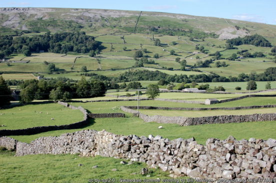
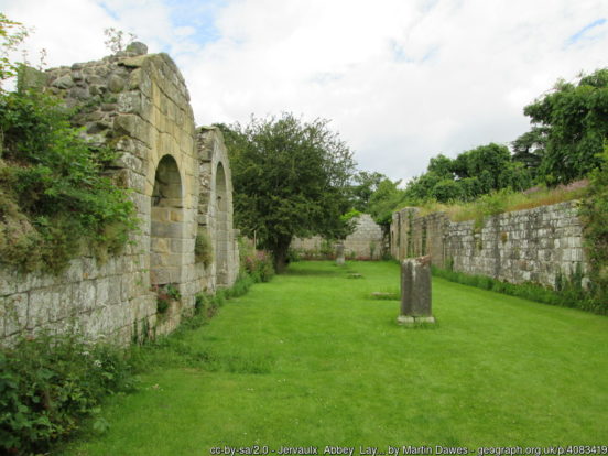
In Wensleydale runs the River Ure, noted for spectacular waterfalls and delightful villages. In the upper part of Wensleydale is Hawes, home of the Wensleydale Creamery, producers of the famous Wensleydale Cheese. Lower down the dale is the 14th century Bolton Castle and, lowe still, the haunting ruins of Jervaulx (or Ure Vale) Abbey. Middleham is a small town in the lower part of the dale, dominated by Middleham Castle, started in 1190. The town is a centre for the rearing and training of racehorses, racing being the foremost employer in the town. Nearby is Braithwaite Hall (NT), a 17th-century manor house.
The West Riding
The West Riding is the biggest of the three. It consists of a largely urban south and a rural north, though the division is not clear cut; in among the industrial towns in the south of the riding are many picturesque villages giving the quintessence of the ordinary Briton’s understanding of Yorkshire. The border with the East Riding is formed by the River Ouse from the city walls of York to the Humber. The border with the North Riding is formed by the Ouse and Ure running northwards, with some minor deviations, as far as Grewelthorpe, from whence it crosses many of the peaks between Wensleydale and the dales to its south, meeting the Westmorland border at Swath Fell Pike.
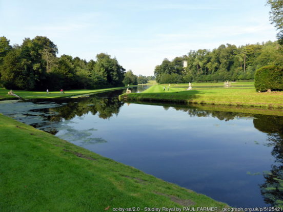
Ripon lies in lower Wensleydale, just to the south of the River Ure. Dominating the city is Ripon Cathedral, whose Gothic appearance hides a more ancient foundation; its undercroft is from the earliest days of English Christianity. Outside the town is Ripon Racecourse. A few miles West of Ripon, by the River Skell, lies the superb UNESCO World Heritage site of Fountains Abbey and Studley Royal Park – the picturesque and extensive ruins of the 11th Century Cistercian monastic foundation and the nearby 18th Century water garden and deer park. Newby Hall, three miles south-east of Ripon, has one of Britain’s finest Adam interiors with Chippendale furniture, Gobelin tapestries and a contemporary sculpture park.
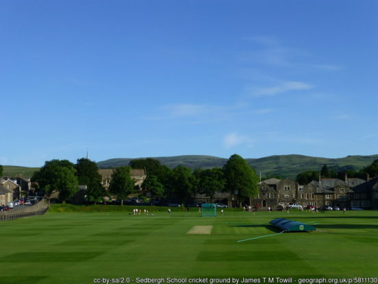
The north and west of the Riding scales the Pennines, including the peaks of Ingleborough, Pen-y-Ghent, and Whernside. The West Riding stretches out to Sedbergh, in the dale of the River Rawthey at the foot of the Howgill Fells and close to the border of Westmorland. The Main Street is lined with shops, notably bookshops, the small town marketing itself as ‘England’s Book Town’. The Clough River flows west through Garsdale to meet the Rawthay north-east of the town. The River Dent flows north-west through Dentdale to meet the Rawthay south-west of Sedbergh.
Ribblesdale is the dale of the River Ribble, which rises near the famous Ribblehead Viaduct. Towns and villages in Ribblesdale (downstream, from north to south) include Horton-in-Ribblesdale, Stainforth, Langcliffe, Giggleswick. Settle, Long Preston and Hellifield. The small market town of Settle is famous for being the starting point of the Settle-Carlisle railway line, the first stretch of which heads north through Ribblesdale. Below Hellifield the valley is generally known as the Ribble Valley, in which guise it flows on into Lancashire and, eventually, the Irish Sea.
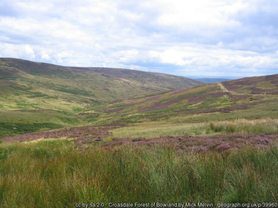
The dale of the River Wenning lies to the north-west of Settle. The River rises at Clapham and then flows westwards through High Bentham, Low Bentham and into Lancashire before eventually joining the River Lune. This dale can be considered an upper part of Lonsdale. To the south of this dale, and west of the Ribble Valley, lies the Forest of Bowland, a huge area of gritstone fells, deep valleys and peat moorland, once described as “the Switzerland of England”. In Bowland the western edge of Yorkshire is only 8 miles from the Irish Sea. A picturesque road passes through the Trough of Bowland linking the charming village of Slaidburn with Lancaster.
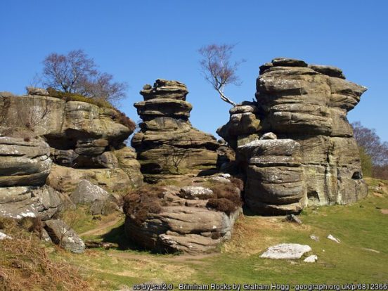
Nidderdale carries the upper reaches of the River Nidd, which rises on the slopes of Great Whernside and flows south through the dale and then eastward into the Vale of York. The only town in the upper dale is Pateley Bridge. Brimham Rocks, further down the dale, is known for its water- and weather-eroded rocks, which were formed over 325 million years ago and have assumed fantastic shapes. The Nidd passes just north of the famous spa town of Harrogate, whose attractions include its spa waters, RHS Harlow Carr Gardens, and Bettys Tea Rooms. Ripley Castle is a 14th-century country house, three miles north of Harrogate. The house is built of coursed squared gritstone and ashlar with grey slate and stone slate roofs. The castle has been the seat of the Ingilby baronets for centuries. Just east of Harrogate is Knaresborough, an historic market and spa town, with the remains of Knaresbrough Castle, Mother Shipton’s petrifying well and several cave dwellings and a chapel dating from the Middle Ages.
Wharfedale is the dale formed by the River Wharfe from its source at Beckermonds, high in the fells, down to the town of Wetherby. The section from the river’s source to around Addingham is known as Upper Wharfedale and, high in the fells, has a rather different character to the rest of the dale. This stretch includes the village of Hubberholme, famous for its church, the resting place of the writer J. B. Priestley. As it turns southwards, the Wharfe then runs through a green and lush valley, with limestone outcrops, such as Kilnsey Crag. Bolton Abbey was founded in 1154 by the Augustinian order, on the banks of the River Wharfe. The priory was abolished at the Dissolution though the nave of the abbey church survives as Bolton Priory Church.
Below Addingham, Wharfedale broadens and turns to the east and on to the towns of Ilkley, Otley and Wetherby. Ilkley is a spa town, characterised by Victorian architecture, wide streets and floral displays. Ilkley Moor is a wild, beautiful moorland and the subject of a folk song “On Ilkla Moor Baht ‘at”, considered the unofficial anthem of Yorkshire. Otley became a major centre of the printing industry following the development of the Wharfedale Printing Machine. Downstream is Harewood House, an 18th-century country house built for Edwin Lascelles, a wealthy West Indian plantation and slave-owner. The house is renowned for its stunning architecture and exquisite Adam interiors. The landscape was designed by Capability Brown. Wetherby is a lovely market town, for centuries a crossing place of the Wharfe and a staging post on the Great North Road.
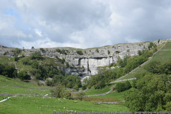
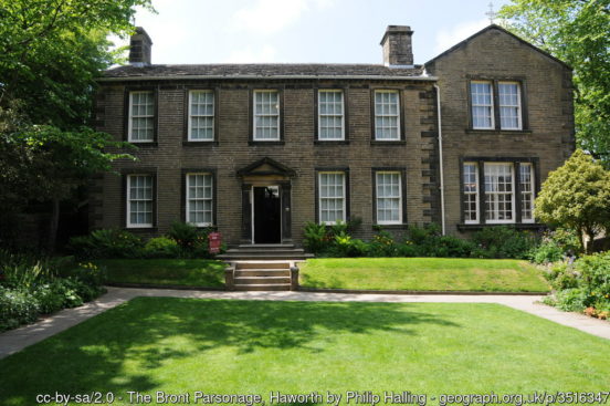
Airedale, the valley of the River Aire, stretches from the source of the River Aire in Malham, and runs down to the pretty, peaceful market town of Skipton. Near the source of the Aire, the pretty village of Malham gives access to two famous geological marvels of Yorkshire. Malham Cove is a large curved limestone formation formed by a waterfall carrying meltwater from glaciers at the end of the last Ice Age. A large limestone pavement is above the cove. Gordale Scar is a limestone ravine containing two waterfalls and with overhanging limestone cliffs over 330 feet high. At Skipton is Skipton Castle, built in the 12th century and the scene of action up to the Civil War. Past Skipton the dale broadens into the the Aire Valley, in which guise it flows down to the former mill town of Keighley. The town is the terminus of the Keighley and Worth Valley Railway, a heritage steam branch line that passes through Haworth to Oxenhope. The parsonage at Haworth, now the Brontë Parsonage Museum, was the childhood home of the Brontë sisters.
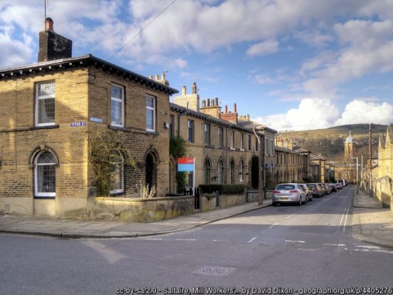
From Keighley the Aire flows down to Bingley, formerly a coaching stop and industrial town with a good deal of heritage from those ages remaining. Further down river is the Victorian model village of Saltaire, a UNESCO World Heritage Site. Saltaire was built in 1851 by the industrialist Sir Titus Salt to site his large textile mill by the Leeds and Liverpool Canal and the railway. Salt built neat stone houses for his workers, wash-houses, bath-houses, a hospital and an institute for recreation and education, with a library, a reading room, a concert hall, science laboratory and a gymnasium. The village has survived remarkably complete. Just east of Saltaire is Shipley, a former industrial town now largely a northern suburb of Bradford. Below Shipley the River Aire flows on to Leeds and Castleford.
The town of Barnoldswick lies on the lower slopes of Weets Hill, astride the natural watershed between the Ribble and Aire valleys. Barnoldswick is the highest town on the Leeds and Liverpool Canal. For hundreds of years, Barnoldswick remained a small village. However, the arrival of the canal helped it to become a major cotton town.
The area in the west of the West Riding is traditionally known as Craven, a term which stretches back to before Domesday. Craven’s extent cannot be defined with precision, but it encompasses lands in the Yorkshire Pennines including the upper reaches of Airedale, Wharfedale, Ribblesdale, the Forest of Bowland and Upper Lonsdale (River Wenning).
To the south of the Dales, the Yorkshire border with Lancashire, Cheshire and Derbyshire follows the roughly north-south line of the Pennines. The market town of Todmorden famously stands across the county border between Yorkshire and Lancashire. The border is formed by the original course of the River Calder and its tributary, the Walsden Water, which run through the centre of the town, across the cricket pitch and through the Town Hall. The fine carved stonework on the town hall’s pediment has a representation of Lancashire (cotton spinning and weaving industries) on one side and of Yorkshire (engineering and agriculture) on the other. The Calder cuts a dale, Calderdale, though the Pennines, the small market town of Hedben Bridge lying at the meeting of the Calder with the Hebden Water.
Saddleworth is an area of Yorkshire to the west of the Pennines. Saddleworth’s villages lie scattered across beautiful landscape, some in the upper dale of the River Tame and others high on the fell slopes of Saddleworth Moor. The largest of the villages of Saddleworth are Uppermill, Greenfield, Dobcross, Delph and Diggle, none of them large, some reflecting the rural ideal of the Yorkshire dales, other reflecting the influence of the suburban spread out of south Lancashire which they border, but all with their charm. Yorkshire, Lancashire and Cheshire meet in a “Y” on the River Tame at Mossley, a small town which lies partly in each of the counties. The Yorkshire part, Roughtown, is to the north, on the west side of the Tame.
The far south-western parts of the West Riding lie within the Peak District bordering the ‘panhandle’ area of Cheshire and north-east Derbyshire. Several small towns lie along the eastern side of the hills. Meltham lies within the Holme Valley, below Wessenden Moor. Holmfirth, also in the Holme Valley, is a delightful little town of stone-built cottages, the sights of which are familiar to many as it provided the setting for the long-running situation comedy Last of the Summer Wine. Penistone has a town centre at 750 feet above sea level. Stocksbridge, in the steep-sided valley of the Little Don River, is famed for its steel-making industry.
Only a small area of the West Riding lies in the Vale of York. In this area lies Tadcaster, a modest market town on the Great North Road and the lowest town on the River Wharfe before it joins the River Ouse. Those suburbs of York itself, outside the city walls, which lie in the West Riding include Nether Poppleton, Upper Poppleton, Beckfield, Acomb, Holgate, Chapelfields, Westfield, Foxwood, South Bank and Dringhouses.
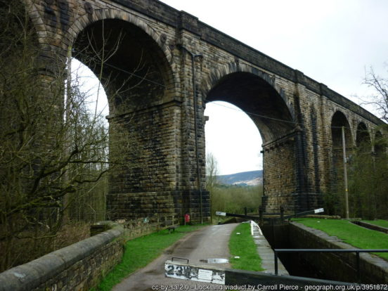
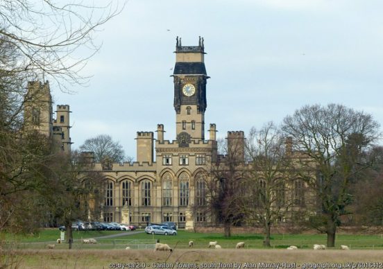
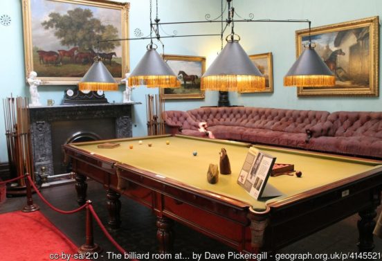
A part of the Humberhead Levels occupies the south-east of the West Riding. Selby stands on the banks of the River Ouse. The Ouse was long the source of Selby’s prosperity, as from the banks of the tidal river Selby became an important port and once had a large shipbuilding industry. The magnificent, cathedral-like Selby Abbey, dating from around 1100, dominates the town centre, a rare example of an abbey church surviving the dissolution of the monasteries without conversion into a cathedral. Carlton Towers, south of Selby, is a large country house in the Victorian Gothic-revival style and surrounded by a 250-acre park. The interior boasts original Victorian features including three grand Staterooms and a Minstrel’s Gallery.
Goole is an inland port town on the tidal River Ouse, where the River Don enters it, some miles above the point at which the Ouse and Trent combine to form the Humber. The towns of Hatfield, Stainforth and Thorne lie in close proximity to each other, close to the Lincolnshire border over which lies the Isle of Axholme. Doncaster is a large town which lies at the edge of the Humberhead Levels: an ancient town, but its modern history comes from the Industrial Revolution, in which it was a coal town and transport centre. Brodsworth Hall, north-west of Doncaster, is one of the most complete surviving examples of a Victorian country house in England, virtually unchanged since the 1860s.
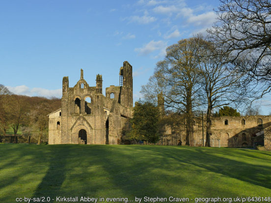
Much of the south-east of the West Riding is heavily urbanised. There are two major urban area. The more northerly of these is based around Leeds, Bradford and Wakefield. Leeds, built on the River Aire, is the commercial and financial centre of Yorkshire. Leeds is an ancient town but its rapid growth is only since the Industrial Revolution, building itself first on wool manufacturing but then with all industry. Temple Newsam is a Tudor-Jacobean house in the south-east of Leeds, with grounds landscaped by Capability Brown. The Henry Moore Institute is a centre for the study of sculpture. Kirkstall Abbey is a ruined Cistercian monastery in Kirkstall, north-west of Leeds city centre.
Bradford, in the foothills of the Pennines, rose to prominence during the 19th century as an international centre of textile manufacture. Since the decline of its traditional industries, Bradford has emerged as a tourist destination with attractions such as the National Science and Media Museum and Cartwright Hall art gallery. Bradford Cathedral dates from the 14th-century.
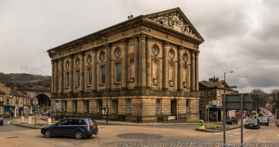
Wakefield stands on the banks of the River Calder on the eastern edge of the Pennines. Wakefield became an important market town and centre for wool, exploiting its position on the navigable River Calder to become an inland port. Wakefield Cathedral has Anglo Saxon origins and the tallest spire in Yorkshire (247 feet). Nostell Priory (NT) is a Palladian house dating from 1733, located in Nostell, close to Wakefield.
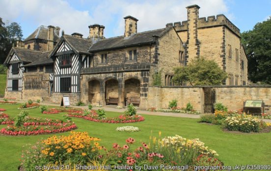
There are several other major towns in the area. As well as for Mackintosh’s sweets, Halifax is famous for its Building Society, formerly the world’s biggest, which became the Halifax Bank, and for ‘catseyes road studs’ invented and manufactured in the town. Shibden Hall is a historic house located in a public park in nearby Shibden. Its Tudor half-timbered frontage remains its most recognisable feature. Huddersfield, near where the Rivers Colne and Holme meet, is known for its role in the Industrial Revolution, for being the birthplace of rugby league and birthplace of the British Prime Minister, Harold Wilson. Dewsbury stands on the River Calder surrounded by hills dominating the views from the town. Dewsbury Minster stands near the Calder. Pontefract is an historic market town standing close to the Great North Road. it is known for Pontefract Castle and Pontefract Cakes. Other small towns in the area include Elland, Brighouse, Batley, Pudsey, Horsforth, Ossett and Normanton.
In the far south of the West Riding is another heavily urbanised based around Sheffield, Rotherham and Barnsley. The great city of Sheffield was built on steel and the coal underneath which powered it mills. Sheffield had been famous for its steel since the Middle Ages but the nineteenth century saw explosive growth, the city climbing unchecked over the steep slopes of its seven hills and spilling over into Derbyshire.
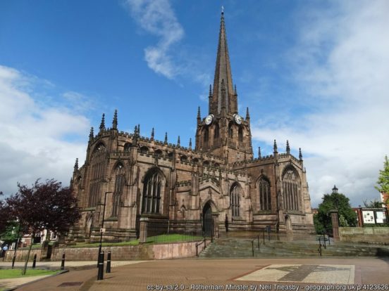
Rotherham lies to Sheffield’s north-east. Rotherham Minster in All Saints Square dates from the 15th century and includes parts from earlier Saxon and Norman structures. It was described by Pevsner as “the best perpendicular church in the country”.
Barnsley stands on the River Dearne, 12 miles north of Sheffield. Barnsley is known as a former industrial town once centred on coal mining and glassmaking. Barnsley has a tradition of brass bands, originally created as social clubs for its mining communities.
Other small towns in the area include Mexborough, Hoyland, Wombwell, Thurnscoe, Wath upon Dearne and Hemsworth. Wentworth Woodhouse, between Rotherham and Barnsley, is a stately home with the longest façade of any country house in England. It stands in 87 acres of gardens and grounds and has extensive views over former parkland. Cannon Hall, west of Barnsley, is a stunning Georgian country house museum set in 70 acres of historic parkland and beautiful landscaped gardens.
Yorkshire abounds in prehstoric remains, including burial monuments on the North York Moors and the Wolds and stone monuments in the Vale of York. There are hill forts throughout the county, the most impressive being at Stanwick in the North Riding.
The Romans had conquered all of the area which later became Yorkshire by the 1st century and garrisoned the town of Eboracum (York). The area served the Romans as a stronghold from which to repel invasions from the north. After the Romans left, several small kingdoms arose in the region. The Angles established themselves on the coast and around the Humber and founded the kingdom of Deira in the late 6th century and eventually conquered most of what became Yorkshire. During the 7th century Deira fell under the domination of Northumbria, York becoming the seat of an archbishop and the ecclesiastical centre.
In 866 the Danes conquered Eoforwic (York), renaming it Jórvík and making it the capital city of a new Danish kingdom under the same name. The area which this kingdom covered was roughly equivalent to the borders of Yorkshire though extending further west. Though the Danes went on to conquer an even larger area of England, most of this area (“the Danelaw”) remained English land, albeit in submission to Viking overlords. The Kingdom of Jórvík was the only truly Viking territory on mainland Britain. The Danes organised Yorkshire into wapentakes and the wapentakes into three areas which all met at the capital, Jörvik. These thirds were each called a thridjungr, which became thriding and ultimately Riding in English.
After around 100 years of its volatile existence, the Kingdom of Jorvik finally came to an end. The Kingdom of Wessex established its dominance over the North in general, placing Yorkshire again within Northumbria, though Yorkshire remained strongly Anglo-Scandinavian in culture. The name Yorkshire first appeared in writing in the Anglo-Saxon Chronicle in 1065. In the weeks leading up to the Battle of Hastings, Harold II of England was distracted by pushing back efforts to reinstate the kingdom of Jorvik. Harold defeated the armies of his brother Tostig and Harald Hardrada, King of Norway, at the Battle of Stamford Bridge, three weeks before his own defeat at Hastings.
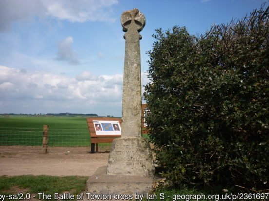
Following the Norman Conquest, all resistance to Norman rule was crushed and wealthy Norman families established large landed estates. Benedictines, Augustinians, and Cistercians founded important monasteries in Yorkshire over the next two centuries. The conversion of much of Yorkshire’s cropland to sheep pasture was hastened by the Black Death in the 14th-century. The wool trade flourished and, with it, Kingston upon Hull flourished as a wool port. The county was the location for two of the most important battles of the Wars of the Roses. At Wakefield (1460), Richard, Duke of York, was slain. At Towton (1461), the Lancastrians were decisively defeated. The Battle of Marston Moor (1644) was one of the crucial battles of the English Civil War. The towns of the West Riding developed cloth making industries from the 14th-century and, during the Industrial Revolution, became a centre of woollen textile manufacturing. The development of the railways in the 19th century encouraged the expansion of coal mining in the West Riding and the development of the iron and steel industries of Sheffield, Rotherham, and Doncaster. Industrialisation spurred the growth of the urban centres of the West Riding which still contain most of the county’s population. Coal mining, steel production, and textile manufacture declined during the late 20th century, to gradually be replaced by service industries, engineering and electronics.
The emblem of Yorkshire is the White Rose of the English royal House of York. The Yorkshire Flag is the White Rose on a blue background.
8 thoughts on “Yorkshire Day – 1st August”
The Ribble flows through Lancaster and eventually into the IRISH Sea, not the North Sea.
Thanks. Fixed this error now.
You are welcome. Keep up the good and interesting work !
Are you Peter Boyce who was involved with the Gloucestersire Canals.?
No. There must be another Peter Boyce out there!
Maritime county are we? I was born in Headingly 74 years ago and it is the first time I’ve heard the County being called such. You miss too many historical facts while labouring on things of little interest. I wonder why you missed The Ainsty when writing of York?
I also wonder why you have given Ilkley such a small pitch when the area is full of historical information? In 1859 Darwin took the waters at Wells House Hydropathic Establishment in Ilkley during the time his major book was published.
That the land hereabouts was settled four thousand years ago. Why are toffees historically more important than one of the worlds leading scientists?
Missing historical facts does nought for those who live within our boundaries.
Yorkshire has usually been described as a ‘maritime county’ in reference works, gazetteers etc. The county does, after all, have a huge coastline and many towns and villages whose history, heritage and way of life is shaped by the sea.
This was intended to be a brief overview of Yorkshire rather than an exhaustive history. Inevitably we have had to be selective with what is included. We are delighted though for things we have omitted to be highlighted in the comments as you have done.
“I, Lord Frazer Irwin standing here in the West Riding of Yorkshire declare:
That Yorkshire is three Ridings and the City of York, with these Boundaries of 1146 years standing;
That the address of all places in these Ridings is Yorkshire;
That all persons born therein or resident therein and loyal to the Ridings are Yorkshiremen and women;
That any person or corporate body which deliberately ignores or denies the aforementioned shall forfeit all claim to Yorkshire status.
These declarations made this Yorkshire Day 2021.
Yorkshire forever, God Save the Queen